The RUC was showing good CAPE and decent directional shear, with southerly surface winds, likely to set up in central MO by later afternoon, but then the 16:30Z SPC outlook showed some interest in NE MO. I debated the two areas, but just before I headed out, decided to stick with central MO, as isolated cells were already forming there down the line from the more numerous ones that had broken out in NE MO. (Good decision, since the stuff in NE MO quickly lined out.) I headed out around 12:30, and promptly lost a half hour due to construction in the St. Louis area (another reason to avoid MO, at least if you live in IL!). Stopped for a data check at the Flying J west of Warrenton, noted an isolated cell at the western edge of Montgomery Co and a stronger one approaching Lake of the Ozarks. Checked out the Montgomery Co one, but it crapped out, so I pushed south through Herman and west on route 100 - which must be the slowest, hilliest, curviest road I have ever been on in a chase. Then, when I thought it could not get worse, the train! (At least it gave me some time to study the maps and plan my intercept route based on the warnings I was hearing on the Lake of the Ozarks storm, which continued to strengthen).
I had figured that the storm, though reported moving NE, would pass south of Jefferson City, which is why I crossed the Missouri River at Herman. Now the movement was reported as east. Up to around 4, all of the reports were of movement between 15 and 25 mph, so I figured I could intercept the storm by heading west from route 100 on route 50, then south on 63 for an intercept west of Freeburg or Vienna. However, after 4 I began hearing reports of movement at 35-40 mph, and when I heard in Feeburg at 4:20 that the storm would reach Vienna by 4:30, I knew I was S.O.L.
The storm had ragged lowerings on the SE side, and although movement was reported as east, it really appeared to me to be moving SE. By the time I was halfway between Freeburg and Vienna - and hearing that the wind was estimated at 70 mph with penny sized hail, I could see that the storm would beat me to Vienna and I could not safely punch through - in a wooded area, I don't want to mess with 70 mph winds. And by now it really had that look - a lowering halfway to the ground (shelf cloud, I would guess, but I was at the wrong angle to tell for sure what it was) and a rain foot surging ahead of the storm in the direction it was moving, it looked every bit as nasty as it was reported. So, as I entered the first of the heavy rain and wind, I reluctantly turned around. Never even got a picture, as up to the minute I realized I had to turn back, I was hustling to beat the storm.
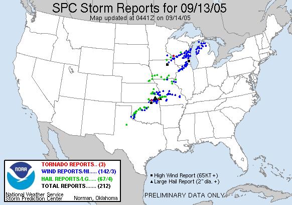
I went back north to route 50, hoping I might get back ahead of the storm for another look as I headed back east. But it was not to be. As I suspected, when I got home and looked at a radar loop, it confirmed that the storm had started moving NE, then turned SE, producing wind damage and some hail from the Lake of the Oazrks areaE then SE to Steeleville and from there all the way ESE to Fredrickstown in Madison Co, MO. The curving track of this storm across central into southeast Missouri can clearly be seen on this storm reports image from SPC. Local storm reports (edited to show reports from this storm only) from the Sringfield NWS office can be seen here and from the St. Louis NWS office here.
This storm seemed to start out as a supercell, then evolve into something like a supercell imbedded in a line of weaker storms - but it did seem to become more of a forward-propagating, outflow-dominant storm around the time I got within range of it, which probably accounts for the acceleration and SE motion. If I had not had the construction or the train, and if I was not so hopelessly road-screwed (as always seems to happen in central MO), maybe I could have gotten ahead of it, but this day that was not to be.