Uncertainty about forecast kept me home longer than I wanted to be - there were a lot of possibilities, all uncertain. ETA predicted a high energy-helicity index in SE Missouri, but it was hard to see a trigger. SPC was interested in an outflow boundary across central/southern MO into eastern Kansas. (It never did fire.) There was a cold front to the NW, but south of the Iowa border it was progged to back west as a warm front. All this suggested the possibility of a long drive into questionable chase country, with very uncertain results - so I sat tight. Around 4:00 storms began to fire in NW Illinois and northeast MO, but the closest possible intercept was 3 hours away - so I waited to see if they would backbuild. They were down to Quincy by 5:00, still better than a 2 hour drive with 3 hours of sunlight - questionable at best. Severe T-storm watches now up from just northwest of our area all the way north to Lake Superior, with obvous supercells in Wisconsin. We ate an early supper, then I checked radar again around 6:20. New cell forming along the Greene-Scott Co. line, if this showed signs of intensification the chase was on - I could intercept it in northern Macoupin Co. and still have maybe an hour of daylight. It rapidly intensified, so I grabbed my maps, cameras, and radio and headed out. Alice decided not to go as it had been a long hard day at work.; she just wanted to rest.
I headed out from Edwardsville around 6:40 p.m. An intense storm had quickly developed along the line of Scott and Greene counties. Since other storms had been moving east around 20-25 mph, I figured this would move into NW Macoupin Co. and I could intercept it northwest of Carlinville around 7:30. As I approached Carlinville from the S and E, I could see a rock hard updraft tower leading into a large anvil backsheared to the SW; most of the anvil was drifting off to the E or ESE. It took a little longer than I thought to get in position, but by 7:40 I was northwest of Carlinville and in rapidly improving view of the storm. I had proceeded up I-55 from Edwardsville to IL route 108, west on that to Carlinville, north on 4 about a mile, then gradually northwest on various back roads. I did not know it due to poor radio reception, but by now, virtually all of Illinois from my location north was under a tornado watch.
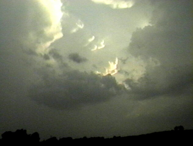
I could see a large wall cloud in the distance by around 7:35. Around 7:40 I stopped about 3 miles SE of Palmyra and watched the wall cloud. At first it seemed attached to the rainfree base to the SW of the precipitation core to my north. Further down the flanking line there was another cell a couple miles WSW of the wall cloud. Just off the flanking line farther to the SW was another large, intense storm, the top of which was really being lit up by the lowering sun. It had a rock hard tower, too, and knuckled anvil just to the north of the tower. I could not see the base of this storm. As I watched the wall cloud it seemed now to be separate from the RFB, which was closer to me, with a clear slot between - RFD? Or maybe there had been a gap all along but I couldn't see it when I was farther away. On reviewing the video, I think the gap was there all the time - the large wall cloud was under a higher RFB to the north of the leading one. In any case, I found out later that there were severe T-storm warnings issued around 7:45 based on radar indications of severe storms near the locations of both the wall cloud to my NW and the knuckled storm to my SW. (All of the warnings that were issued on this storm can be seen here.) The wall cloud briefly shrank, then developed an inflow tail on its east side and rapidly grew. It appeared to reach most of the way to the ground. (This video snap will take a little longer to load than the others - due to limited contrast I didn't convert it to jpeg compressed.) Then, however, rain began to cascade from the base between me and the wall cloud and it disappeared in the time of a minute or two. This would have been around 7:50.
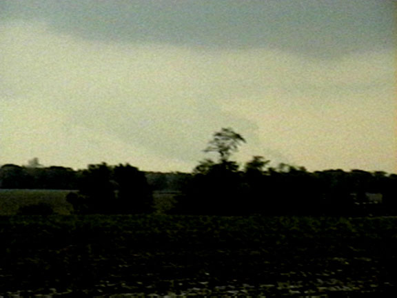
I headed west to where 2700N intersects Il route 111 about 2.5 miles S. of Palmyra. I stopped here for about 5-10 minutes around 8:00 p.m. watching the RFB to the west of line of heavy precip that had obsured the earlier wall cloud. Suddenly rising scud appeared, and after a minute or so morphed into a solid lowering that briefly looked like a funnel - but I could see little or no rotation. Then, it evolved into a more typical-looking wall cloud. This lowering would have been near or just southwest of Palmyra. To its southwest, another lowering formed; this one clearly had the appearance of an inflow tail with inflow from the southwest. Again there was a new (and stronger-looking) cell to the west, probably a couple miles SW of Palmyra. Again the wall cloud quickly occluded, and I was faced with an onrushing wall of heavy precip, with who knows what imbedded or behind the precipitation shafts. At the same time, the storm to the SW was threatening to cut off my escape route to the S. I quickly headed south on 111, encountering intense rain in huge drops and perhaps a few small hailstones near Hettick. A new lowering formed on the SW edge of what had been the knuckled storm, just W or Hettick. As it was getting dark, I decided to head east through Carlinville and back to I-55 to head home.
As I headed east, I noticed a large cloud form under the updraft base to my NW, but separate from it, with a small lowering underneath. I would have attributed more significance to it had it been attached, but it wasn't. Other scuddy lowerings formed nearby. Around 8:20 I head a tornado warning for northern Macoupin Co. based on a spotter report of a funnel 1 mile NE of Palmyra, moving east - the storm I had just been on 15 minutes earlier! I stopped to look north, but the precip from the Hettick storm blocked my view. It looked like the storms were merging (confirmed later by radar loop. This storm is the southernmost one in the loop. In the first frame the line of storms to the southwest of the main storm can be seen, but in later farmes, there is just the one supercell.). There was a lot of CG lightning but only scuddy lowerings visible from my viewpoint. At this time there was strong inflow from the south, which I would estimate at 25-30 mph. The St. Louis LSR indicates that at 8:16 p.m. there was a tornado with a damage path 1-2 miles long about 3 miles east of Palmyra. This would put it just 2 miles north of where I had videotaped the first large wall cloud about a half hour earlier. Given the slow movement of the storm to the ESE, I think this large wall cloud was the most likely source of the tornado, though the other one I saw around 8:00 could possibly have been. All of the local storm reports associated with this storm can be seen here
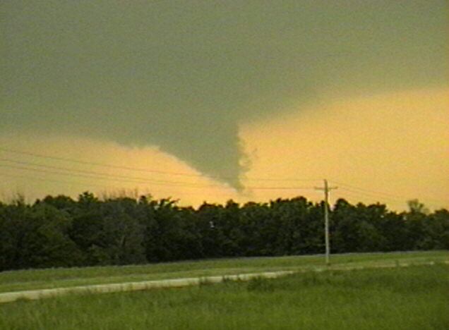
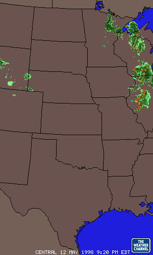
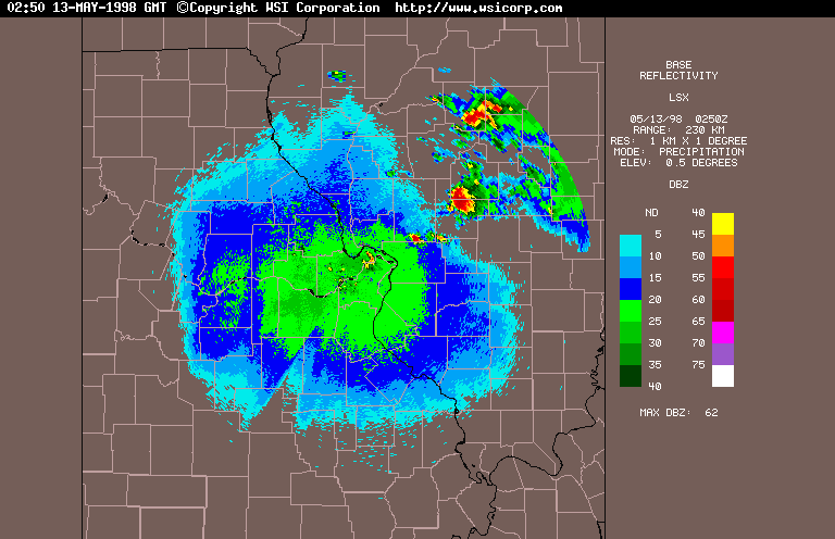
I headed on around 8:30, passing through Carlinville. East of Carlinville at 8:45 I noticed a beavertail to my NE, well lit by lightning (the only way I could see it, since it was now totally dark), extending toward the ESE from the heaviest core of the storm. The lightning was now almost continuous - more than a flash a second. I stopped again around 8:50 to watch and tape the lightning. Scuddy lowerings formed on a shelf cloud or RFB to my WNW and, farther away to my NNW, I could occasionally see a large, rain-wrapped lowering. The front edge extended toward the ground at a 45-degree angle; it was wide but I could not tell just at the time how wide - I could only see it 3 or 4 times when lightning flashed behind it; clearly most of the rain and lightning was between me and it. This occurred around 8:55. A review of the video suggests what may be a cone-shaped lowering, apparently a rain-wrapped funnel or possibly tornado. The time and place are directly between the two reported tornadoes, so that makes sense. There is, however, no report at this time of a tornado in this location at this time, so funnel is most likely the correct call. Here are two video snaps of this feature taken 3 seconds apart, with some additional info. I should add that I saw no power flashes, just lots of lightning. I heard a statement on the weather radio from STL that radar had indicated a severe storm with a possible tornado approaching Nilwood around 8:50, which also would correspond well with where this lowering was a few minutes later. I watched the storm until about 9:05, then headed home. The storm did, about an hour later, produce a spotter-reported tornado west of Witt, or 17 miles SW of Taylorville. That tornado was reported at 10:16 p.m. Here is a radar image of the storm at 9:50 p.m.
All in all, a very interesting chase for a day when I couldn't make up my mind what to do until around 6:30! There were six tornadoes reported in Illinois; two came from this storm. Total chase distance: about 130 miles.
One other thought - for most of its life this storm had an individual, supercell configuration. It was a slow mover, slightly to the right of the west to east movements of other storms. But from around 7:40 to 8:15 it temporarily became multicellular, as storms went up on the flanking line as well as the cell just to the southwest. But these all merged back into the storm - apparently around the time of the tornado east of Palymra - and from about 8:30 to past 10:30, the storm again had the appearance, visually and on radar, of a single large supercell. Later still, it died out in northwest Fayette County after 10:30, but several other cells went up just to the west in Macoupin and Montgomery Counties producing reports of large hail.
Comments to jfarley@siue.edu
Here are all the warnings issued for this storm:
561
WUUS1 KSTL 130049
SVRSTL
ILC117-130150-

BULLETIN - IMMEDIATE BROADCAST REQUESTED
SEVERE THUNDERSTORM WARNING
NATIONAL WEATHER SERVICE ST LOUIS MO
749 PM CDT TUE MAY 12 1998

THE NATIONAL WEATHER SERVICE IN ST LOUIS HAS ISSUED A

* SEVERE THUNDERSTORM WARNING FOR...
MACOUPIN COUNTY IN SOUTHWESTERN ILLINOIS

* UNTIL 850 PM CDT

* AT 746 PM...NATIONAL WEATHER SERVICE DOPPLER RADAR INDICATED
SEVERE THUNDERSTORMS NEAR GREENEFIELD AND ANOTHER STORM 8 MILES
NORTHWEST OF PALMYRA... MOVING EAST AT 20 MPH.

* LOCATIONS THAT WILL BE AFFECTED...
GERRARD
VIRDEN
MODESTO
HAGAMAN
READER

SEVERE THUNDERSTORMS PRODUCE DAMAGING WIND GUSTS IN EXCESS OF 60
MPH...DAMAGING HAIL...DEADLY LIGHTNING...AND VERY HEAVY RAIN. MOVE
TO AN INTERIOR ROOM ON THE LOWEST FLOOR OR YOUR HOME OR BUSINESS.
HEAVY RAINS FLOOD ROADS QUICKLY SO DO NOT DRIVE INTO AREAS WHERE
WATER COVERS THE ROAD.

A TORNADO WATCH IS ALSO IN EFFECT FOR THE WARNED AREA. SEVERE
THUNDERSTORMS CAN PRODUCE TORNADOES WITH LITTLE OR NO ADVANCE
WARNING.

FG/DLF

BULLETIN - EAS ACTIVATION REQUESTED
TORNADO WARNING
NATIONAL WEATHER SERVICE ST LOUIS MO
816 PM CDT TUE MAY 12 1998

THE NATIONAL WEATHER SERVICE IN ST LOUIS HAS ISSUED A

* TORNADO WARNING FOR...
NORTHERN MACOUPIN COUNTY IN SOUTHWESTERN ILLINOIS

* UNTIL 905 PM CDT

* AT 810 PM CDT... SEVERE STORM SPOTTERS REPORTED A FUNNEL CLOUD ONE
MILE NORTHEAST OF PALMYRA... MOVING EAST AT 20 MPH.

* LOCATIONS IN THE PATH...
GIRARD
VIRDEN

IF YOU ARE IN THE PATH OF THIS STORM...SEEK SHELTER NOW! A
BASEMENT OFFERS THE BEST PROTECTION. IF NOT AVAILABLE...MOVE TO
THE LOWEST FLOOR AND SEEK SHELTER IN A SMALL INTERIOR ROOM. STAY
AWAY FROM OUTSIDE WALLS AND WINDOWS. MOBILE HOMES SHOULD BE
ABANDONED IN FAVOR OF A MORE SUBSTANTIAL STRUCTURE. DO NOT TRY TO
OUTRUN A TORNADO IN A VEHICLE

METZE/GLASS

SEVERE THUNDERSTORM WARNING
NATIONAL WEATHER SERVICE ST LOUIS MO
843 PM CDT TUE MAY 12 1998

THE NATIONAL WEATHER SERVICE IN ST LOUIS HAS ISSUED A

* SEVERE THUNDERSTORM WARNING FOR...
MONTGOMERY COUNTY ILLINOIS IN SOUTHWESTERN ILLINOIS

* UNTIL 930 PM CDT

* AT 833 PM CDT...NATIONAL WEATHER SERVICE DOPPLER RADAR INDICATED A
SEVERE THUNDERSTORM 5 MILES SOUTH OF GIRARD... MOVING EAST AT 20
MPH.

* LOCATIONS THAT WILL BE AFFECTED...
WAGGONER
RAYMOND

THE PRIMARY SEVERE WEATHER THREAT IS DAMAGING HAIL. LARGE HAIL CAN
CAUSE EXTENSIVE PROPERTY DAMAGE AN SERIOUS INJURY TO PEOPLE CAUGHT
OUTDOORS. MOVE INSIDE A STURDY BUILDING IMMEDIATELY.

A TORNADO WATCH IS ALSO IN EFFECT FOR THE WARNED AREA. SEVERE
THUNDERSTORMS CAN PRODUCE TORNADOES WITH LITTLE OR NO ADVANCE
WARNING.

METZE/GLASS

203
WFUS1 KSPI 130236
TORSPI
ILC021-130330-

BULLETIN - EAS ACTIVATION REQUESTED
TORNADO WARNING
NATIONAL WEATHER SERVICE LINCOLN IL
936 PM CDT TUE MAY 12 1998

THE NATIONAL WEATHER SERVICE IN LINCOLN HAS ISSUED A

* TORNADO WARNING FOR
CHRISTIAN COUNTY IN CENTRAL ILLINOIS

* UNTIL 1030 PM CDT

* AT 934 PM CDT LINCOLN DOPPLER RADAR INDICATED A POSSIBLE TORNADO 20
MILES SOUTH OF SPRINGFIELD...MOVING EAST NORTHEAST AT 20 MPH.

* THIS STORM IS EXPECTED TO AFFECT AREAS AROUND...
MORRISONVILLE
TAYLORVILLE
PANA

IF YOU ARE IN THE PATH OF THIS STORM...TAKE COVER IN A BASEMENT OR
INTERIOR ROOM ON THE LOWEST FLOOR. VEHICLES AND MOBILE HOMES SHOULD
BE ABANDONED FOR A SAFER SHELTER.

FRIEDERS


378
WFUS1 KSTL 130308
TORSTL
ILC135-130355-

BULLETIN - EAS ACTIVATION REQUESTED
TORNADO WARNING
NATIONAL WEATHER SERVICE ST LOUIS MO
1008 PM CDT TUE MAY 12 1998

THE NATIONAL WEATHER SERVICE IN ST LOUIS HAS ISSUED A

* TORNADO WARNING FOR...
NORTHERN MONTGOMERY COUNTY ILLINOIS IN SOUTHWESTERN ILLINOIS

* UNTIL 1055 PM CDT

* AT 1005 PM CDT... NATIONAL WEATHER SERVICE DOPPLER RADAR INDICATED
A TORNADO NEAR WITT... MOVING EAST AT 20 MPH.

* LOCATIONS IN THE PATH...
WITT
COALTON
NOKOMIS

DOPPLER RADAR IS SHOWING A STRONG TORNADO SIGNAL. IF YOU ARE IN
THE PATH MOVE TO A SHELTER NOW! A BASEMENT IS BEST...BUT IF NOT
AVAILABLE...MOVE TO THE LOWEST LEVEL AND HIDE IN A SMALL INTERIOR
ROOM. GET OUT OF MOBILE HOMES AND CARS IN FAVOR OF A STRONG
BUILDING.

METZE/GLASS

467
WWUS34 KSTL 130322
SVSSTL
ILZ060-130355-

SEVERE WEATHER STATEMENT
NATIONAL WEATHER SERVICE ST LOUIS MO
1022 PM CDT TUE MAY 12 1998

...TORNADO WARNING FOR NORTHERN MONTGOMERY COUNTY UNTIL 1055
PM...

AT 1016 PM...NWS SPOTTER REPORTED A TORNADO TO THE WEST OF WITT...
MOVING EAST AT 20 MPH.

COMMUNITIES STILL IN THE PATH ARE WITT...COALTION...AND NOKOMIS.

IF YOU ARE IN THE PATH OF THIS STORM...SEEK SHELTER NOW! A BASEMENT
OFFERS THE BEST PROTECTION. IN NOT AVAILABLE...MOVE TO THE LOWEST
FLOOR AND SEEK SHELTER IN A SMALL INTERIOR ROOM. STAY AWAY FROM
OUTSIDE WALLS AND WINDOWS. MOBILE HOMES SHOULD BE ABANDONED IN
FAVOR OF A MORE SUBSTANTIAL STRUCTURE. DO NOT TRY TO OUTRUN A
TORNADO IN YOUR CAR.

&
METZE


401
WFUS1 KSPI 130313
TORSPI
ILC173-130415-

BULLETIN - EAS ACTIVATION REQUESTED
TORNADO WARNING
NATIONAL WEATHER SERVICE LINCOLN IL
1012 PM CDT TUE MAY 12 1998

THE NATIONAL WEATHER SERVICE IN LINCOLN HAS ISSUED A

* TORNADO WARNING FOR
SOUTHERN SHELBY COUNTY IN CENTRAL ILLINOIS

* UNTIL 1115 PM CDT

* AT 1010 PM CDT...A TORNADO WAS REPORTED 17 MILES SOUTH
SOUTHWEST OF TAYLORVILLE NEAR WITT IN MONTGOMERY COUNTY...MOVING
EAST AT 25 MPH.

* THIS STORM IS EXPECTED TO AFFECT AREAS AROUND...
LAKEWOOD
COWDEN
SHELBYVILLE
STEWARDSON

IF YOU ARE IN THE PATH OF THIS STORM...TAKE COVER IN A BASEMENT OR
INTERIOR ROOM ON THE LOWEST FLOOR. VEHICLES AND MOBILE HOMES SHOULD
BE ABANDONED FOR A SAFER SHELTER.

FRIEDERS
Here are all the local storm reports associated with this storm:
PRELIMINARY LOCAL STORM REPORT
NATIONAL WEATHER SERVICE LINCOLN IL
232 AM CDT WED MAY 13 1998

...ADDITIONAL REPORTS ADDED...

TIME(CDT)  .....CITY LOCATION..... STATE  ...EVENT/REMARKS...
           ....COUNTY LOCATION....

0654 PM    WINCHESTER                IL   1.5 INCH HAIL
05/12/98   SCOTT                          (SHERIFF)

0845 PM    2S DIVERNON               IL   .75 INCH HAIL
05/12/98   SANGAMON                       (ESDA)


PRELIMINARY LOCAL STORM REPORT
NATIONAL WEATHER SERVICE ST LOUIS MISSOURI
1203 AM CDT WED MAY 13 1998

TIME(CDT)  .....CITY LOCATION..... STATE  ...EVENT/REMARKS...
           ....COUNTY LOCATION....

0718 PM    CARROLLTON                IL   .88 INCH HAIL
05/12/98   GREENE                         REPORTED BY GREENE COUNTY
                                          SHERIFFS OFFICE

0721 PM    CARROLLTON                IL   .88 INCH HAIL
05/12/98   GREENE                         REPORTED BY GREENE COUNTY
                                          EMERGENCY MANAGEMENT
                                          DIRECTOR

0750 PM    GREENFIELD                IL   .75 INCH HAIL
05/12/98   GREENE

0806 PM    MODESTO                   IL   1.75 INCH HAIL
05/12/98   MACOUPIN

0811 PM    PALMYRA                   IL   1.25 INCH HAIL
05/12/98   MACOUPIN
0815 PM    1 N PALMYRA               IL   1.75 INCH HAIL
05/12/98   MACOUPIN

0816 PM    3 E PALMYRA               IL   TORNADO
05/12/98   MACOUPIN                       THREE SHEDS AND A GRAIN
                                          BIN DESTROYED - TRUCK
                                          OVERTURNED TIME APPROX -
                                          PATH WITH AROUND 100 YARDS
                                          AND LENGTH 1-2 MILES

0836 PM    GIRARD                    IL   .75 INCH HAIL
05/12/98   MACOUPIN

0846 PM    STANDARD CITY             IL   .75 INCH HAIL
05/12/98   MACOUPIN

1016 PM    5 W WITT                  IL   TORNADO
05/12/98   MONTGOMERY                     REPORTED BY TRAINED
                                          SPOTTER

1030 PM    NOKOMIS                   IL   .75 INCH HAIL
05/12/98   MONTGOMERY