I headed down I-55 and I-255 from Edwardsville, leaving around 4:00. I had been watching the above-mentioned supercell move eastward from Osage Co., MO toward Franklin Co., MO on TWC radar before I left. This would take it to somewhere near the boundaries of St. Clair and Randolph Counties in Illinois, if it continued this motion. Thanks to a couple radar updates from Chris Novy, I knew that this motion was continuing so I took IL route 3 from I-255 to Red Bud, spending what seemed like an eternity stuck in traffic in Waterloo. Finally I reached Red Bud, and as I approached the outskirts a tornado warning was issued for that area based on a radar indication of a tornado near Hillsboro, MO just across the Mississippi River. I headed a little south of Red Bud on route 3 to find a place to watch and wait for the storm.
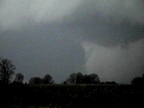
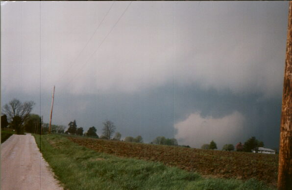
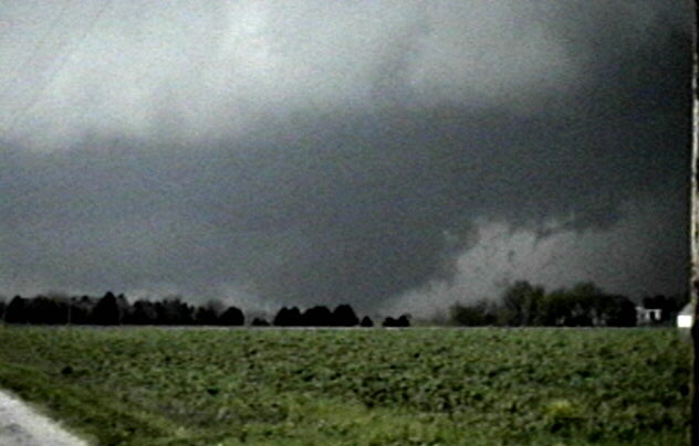
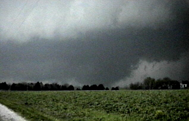
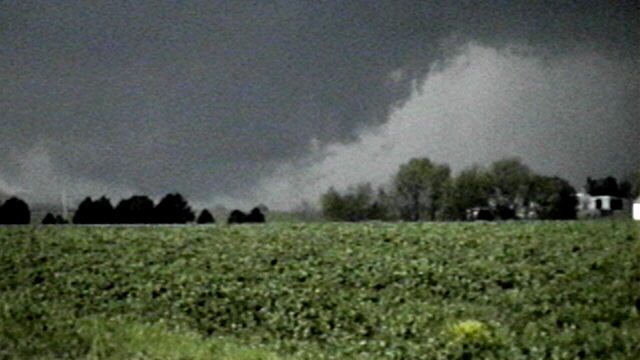
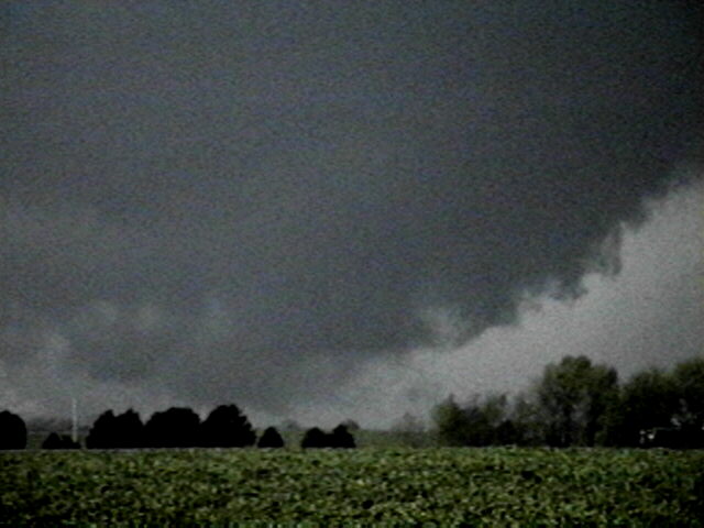
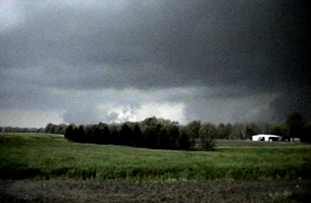
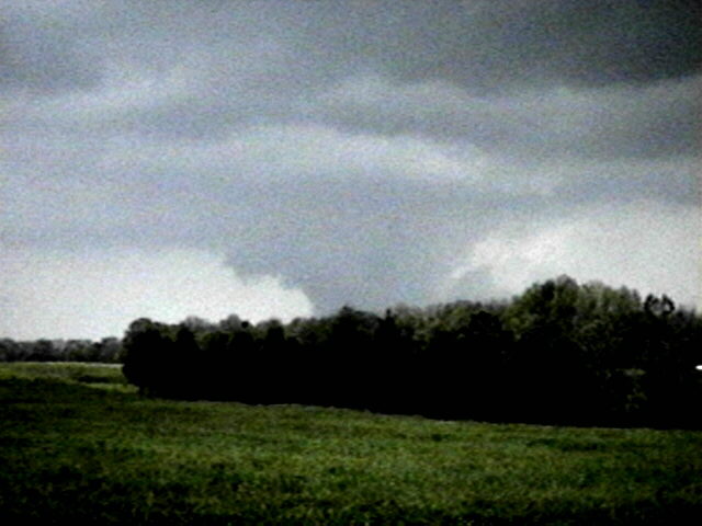
I was in position about 3 miles south of Red Bud, which appeared as best I could see to be east of the storm with a good escape route south, by around 5:30 or so. Around this time another tornado warning was issued based on a radar TVS near Maeystown. As the storm moved toward me, I saw a beavertail on the northeast of what turned out to be the updraft base, extending northeast toward the precipitation area. As the RFB approached me a huge wall cloud became evident. Here is a video snap of this feature, and here is a photo. Some of this lowering was due west of me, so I backed maybe 1/3 of a mile farther south. At that stop - about ten to 6:00 - I saw and videotaped a huge rotating wall cloud that extended almost all the way to the ground (appeared to go all the way at times) and at one point appeared to throw up a cloud of dust or debris - I saw it at the time and can see it on the video. This may in fact be dust or debris, indicating a tornado, or it may be very low scud or hail fog being drawn into the vortex. Jay Antle was viewing this lowering from the north and reports seeing hail fog drawn into it. Whether that was at the same time as I was seeing this or slightly later is not clear. He felt that when he saw the lowering, the wind strength was not strong enough to classify as tornadic. There is also a flash of light - looks like a power flash but could be lightning - in my video at one point in the location where the lowering is closest to the ground. At about this same time there was a spotter report of a tornado near Red Bud, which prompted a warning from STL NWS. (Actually, there were reports of brief touchdowns both west and east of Red Bud.) On the NWS STL local storm report a tornado is reported as briefly touching down 10 miles SE of Waterloo, which would place it about 3 miles W or NW of Red Bud. I was about 3 miles S. of Red Bud looking NW. Based on the possible debris, possible power flash, spotter report, and minor damage I later saw (discussed below) I am classifying this as a "possible tornado," but I would like to emphasize that I am not completely sure about this.
UPDATE, JULY 29 - For what it's worth, the official word in the preliminary edition of Storm Data is that this was a tornado. This is based on spotter reports. Here are entries from Storm Data on it and on the large hail in Red Bud:
Tornado (F0) Injuries - 0 Width (yd.) - 50 Path length (mi) - 0.1 $Damage - 0
10 SSE Waterloo
15 1647CST - 1648CST
Monroe County
Severe storm spotters reported a brief tornado in open country south of Waterloo.
Hail (1.75)
Red Bud
15 1648CST
Randolph County
Spotters reported golfball size hail.
The location reported above - 10 miles SSE of Waterloo - would place the tornado reported by spotters almost exactly in the place I was looking at - about 4 miles WSW of Red Bud. Additional notes: The second touchdown in the preliminary LSR, reported at the east edge of Red Bud, does not appear in Storm Data. This second touchdown may have been discounted. Also, the largest reported hail associated with this storm in Storm Data is 2.75 in. - somewhat smaller than reports of 4.5 in. in some locations that appeared in the LSR.
Here are several video snaps of this possible tornado:
After the storm passed Red Bud it appeared to temporarily weaken or go outflow dominant. I went back to Red Bud to see if there was damage. All I saw was a cemetary at the west edge of town where 4 large trees were down and a lot of branches thrown around. I drove through a subdivision to the south and past a trailer court to the west and saw no visible damage, though people were out pointing to the sky. A KMOX reporter who heard of damage at a trailer court checked it out and found only a few awnings blown down. However, I later found that the trailer court I looked at was not the one where the damage occurred, and at that one, newspapers reported one or two trailers unroofed. Both the KMOX reporter and a St. Louis helicopter crew reported ground deeply covered by hail north or northeast of Red Bud - I saw the copter video at 10:00; pretty dramatic. The Post-Dispatch also had a photo of hail along route 159 north of Red Bud. This hail, which I did not see, was up to golfball size; other areas got up to 4.5 inch diameter hail.
Somewhere between 6:30 and 7:00 - not sure of exact time - I headed ESE toward Sparta on route 154. A TV radar loop I saw later confirmed my visual observations at this time that the storm turned NE somewhere east of Red Bud then morphed into a squall line. I watched this happen as I caught up to a flanking line extending southwest of it between Red Bud and Sparta. I had decided to go over to Sparta 1) to see if anything developed on the flanking line and 2) to avoid driving through a reported hailer moving into Monroe County. As the flanking line looked fairly innocent I crossed under it and went north on route 4 at Sparta. I did notice a somewhat wimpy lowering north of Sparta as I approached Sparta from the West. This feature had moved east by the time I reached Sparta, however. There was also another larger lowering off farther to the east but I lost sight of it in the darkness and poor contrast. Then in the next 15 minutes, as I headed north, everything intensified, a tornado warning went up on the cell NE of Sparta, and the whole flanking line evolved quickly into a squall line, that pounded me with torrential rain and a little hail. There was water on the road in places from flash flooding in nearby fields near Marissa. This would have been around 7:20. I saw a number of low ragged clouds that seemed to form along areas of intersection of inflow and outflow, with lots of CG zapping down all around me. Another tornado warning went up for a storm to my west, but I knew that since I was well due east of the eastward moving meso and headed north that I would be out of the area before it arrived. I picked up route 15 east of Fayetteville and followed it to Belleville to pick up I-255 and return home. Rain continued quite heavy all the way to Belleville, with decreasing lightning after Fayetteville.
I was back in Edwardsville around 8:30. Total chase distance: about 150 miles.
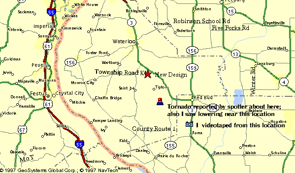
Here is a map showing where I photographed the possible tornado and where the spotter report of a tornado was.
Here is a series of radar images of the storm, including one from the approximate time I witnessed the possible tornado.
Comments to John Farley, jfarley@siue.edu
An unusually large number (for Illinois) of storm chasers were on this storm. Here are reports from others who were on this storm at some point during its life, or on other storms in the immediate area:
Don Lloyd's chase report
Jeff Piotrowski's chase report
Gilbert Sebenste's chase report
Stephen Jascourt's chase report
Jay Antle and John Moser's chase report
405
WFUS1 KSTL 152204
WFUS1 KSTL 152204
TORSTL
ILC133-157-152305-

BULLETIN - EAS ACTIVATION REQUESTED
TORNADO WARNING
NATIONAL WEATHER SERVICE ST LOUIS MO
502 PM CDT WED APR 15 1998

THE NATIONAL WEATHER SERVICE IN ST LOUIS HAS ISSUED A

* TORNADO WARNING FOR...
MONROE COUNTY ILLINOIS IN SOUTHWESTERN ILLINOIS
NORTHERN RANDOLPH COUNTY IN SOUTHWESTERN ILLINOIS

* UNTIL 605 PM CDT

* AT 500 PM CDT... NATIONAL WEATHER SERVICE DOPPLER RADAR INDICATED
A TORNADO NEAR HILLSBORO MISSOURI... MOVING EAST AT 25 MPH.

* LOCATIONS IN THE PATH...
MAEYS
MAEYSTOWN
VALMEYER
RED BUD
RUMA

THIS IS A DANGEROUS SITUATION! IF IN THE PATH...TAKE COVER NOW!
MOVE TO A BASEMENT IF AVAILABLE. IF NOT...STAY ON THE LOWEST LEVEL
AND GO TO A SMALL INTERIOR ROOM. MOBILE HOMES AND AUTOMOBILESHOULD
BE ABANDONED IN FAVOR OF A STRONG STRUCTURE. AS A LAST RESORT...
MOVE TO A DITCH OR CULVERT AND COVER YOUR HEAD.

PEDIGO

&

 WFUS1 KSTL 152226
 WFUS1 KSTL 152226
TORSTL
ILC163-152330-

BULLETIN - EAS ACTIVATION REQUESTED
TORNADO WARNING
NATIONAL WEATHER SERVICE ST LOUIS MO
524 PM CDT WED APR 15 1998

THE NATIONAL WEATHER SERVICE IN ST LOUIS HAS ISSUED A

* TORNADO WARNING FOR...
ST CLAIR COUNTY IN SOUTHWESTERN ILLINOIS

* UNTIL 630 PM CDT

* AT AT 524 PM CDT... NATIONAL WEATHER SERVICE DOPPLER RADAR
INDICATED A TORNADO NEAR MAEYSTOWN IL... MOVING EAST AT 25 MPH.

* LOCATIONS IN THE PATH...
MARISSA
LENZBURG
NEW ATHENS

THE TORNADO AND VERY LARGE HAIL WERE REPORTED WEST OF CRYSTAL CITY

A TORNADO IS ON THE GROUND! IN YOU ARE IN THE PATH...MOVE
IMMEDIATELY TO A SUBSTANTIAL STRUCTURE NOW FOR PROTECTION. A
BASEMENT OFFERS THE BEST SHELTER. YOUR LIFE AND THE LIVES OF THOSE
AROUND YOU MAY DEPEND ON YOUR ACTIONS.

PEDIGO

&


666
WFUS1 KSTL 152249
WFUS1 KSTL 152249
TORSTL
ILC157-152350-

BULLETIN - EAS ACTIVATION REQUESTED
TORNADO WARNING
NATIONAL WEATHER SERVICE ST LOUIS MO
548 PM CDT WED APR 15 1998

THE NATIONAL WEATHER SERVICE IN ST LOUIS HAS ISSUED A

* TORNADO WARNING FOR...
NORTHERN RANDOLPH COUNTY IN SOUTHWESTERN ILLINOIS

* UNTIL 650 PM CDT

* AT 548 PM CDT... NATIONAL WEATHER SERVICE DOPPLER RADAR INDICATED
A TORNADO JUST WEST OF RED BUD IL... MOVING EAST AT 25 MPH.
THE TORNADO WARNING HAS BEEN EXTENDED FOR SEVERAL MORE MINUTES

* LOCATIONS IN THE PATH...
RED BUD
PRAIRIE
BALDWIN
HOUSTON

SEVERAL REPORTS OF LARGE HAIL HAVE ALSO BEEN RECEIVED

THIS IS A DANGEROUS SITUATION! IF IN THE PATH...TAKE COVER NOW!
MOVE TO A BASEMENT IF AVAILABLE. IF NOT...STAY ON THE LOWEST LEVEL
AND GO TO A SMALL INTERIOR ROOM. MOBILE HOMES AND AUTOMOBILESHOULD
BE ABANDONED IN FAVOR OF A STRONG STRUCTURE. AS A LAST RESORT...
MOVE TO A DITCH OR CULVERT AND COVER YOUR HEAD.

PEDIGO


737
WFUS1 KSTL 152300
WFUS1 KSTL 152300
TORSTL
ILC189-160005-

BULLETIN - EAS ACTIVATION REQUESTED
TORNADO WARNING
NATIONAL WEATHER SERVICE ST LOUIS MO
601 PM CDT WED APR 15 1998

THE NATIONAL WEATHER SERVICE IN ST LOUIS HAS ISSUED A

* TORNADO WARNING FOR...
SOUTHERN WASHINGTON COUNTY ILLINOIS IN SOUTHWESTERN ILLINOIS

* UNTIL 705 PM CDT

* AT AT 552 PM CDT... SEVERE STORM SPOTTERS INDICATED A TORNADO NEAR
REDBUD... MOVING EAST 25 MPH.

* LOCATIONS IN THE PATH...
CASPARS
OAKDALE
POSEN

A TORNADO IS ON THE GROUND! IN YOU ARE IN THE PATH...MOVE
IMMEDIATELY TO A SUBSTANTIAL STRUCTURE NOW FOR PROTECTION. A
BASEMENT OFFERS THE BEST SHELTER. YOUR LIFE AND THE LIVES OF THOSE
AROUND YOU MAY DEPEND ON YOUR ACTIONS.

RP/DM


495
 WWUS30 KSTL 161924
 WWUS30 KSTL 161924
LSRSTL

PRELIMINARY LOCAL STORM REPORT
NATIONAL WEATHER SERVICE ST LOUIS MISSOURI
220 PM CDT THU APR 16 1998

TIME(CDT)  .....CITY LOCATION..... STATE  ...EVENT/REMARKS...
           ....COUNTY LOCATION....

0300 PM    META                      MO   1 INCH HAIL
04/15/98   OSAGE

0306 PM    ARGYLE                    MO   1 INCH HAIL
04/15/98   OSAGE                          COVERING THE GROUND

0312 PM    FREEBURG                  MO   .75 INCH HAIL
04/15/98   OSAGE

0339 PM    BLAND                     MO   .75 INCH HAIL
04/15/98   GASCONADE

0350 PM    OWENSVILLE                MO   TORNADO
04/15/98   GASCONADE                      BRIEF TOUCHDOWN SE OF
                                          OWENSVILLE

0350 PM    CANAAN                    MO   1.75 INCH HAIL
04/15/98   GASCONADE

0355 PM    FREEBURG                  MO   .75 INCH HAIL
04/15/98   OSAGE

0355 PM    OWENSVILLE                MO   .75 INCH HAIL
04/15/98   GASCONADE

0356 PM    OWENSVILLE                MO   1 INCH HAIL
04/15/98   GASCONADE

0405 PM    FREEBURG                  MO   .75 INCH HAIL
04/15/98   OSAGE

0414 PM    ST CLAIR                  MO   .75 INCH HAIL
04/15/98   FRANKLIN

0420 PM    ST CLAIR                  MO   1 INCH HAIL
04/15/98   FRANKLIN

0425 PM    GERALD                    MO   1 INCH HAIL
04/15/98   FRANKLIN

0430 PM    ST CLAIR                  MO   4.5 INCH HAIL
04/15/98   FRANKLIN                       SW OF ST CLAIR

0438 PM    STANTON                   MO   1.75 INCH HAIL
04/15/98   FRANKLIN

0439 PM    ST CLAIR                  MO   4.5 INCH HAIL
04/15/98   FRANKLIN                       JUST SE OF ST CLAIR

0442 PM    CATAWISSA                 MO   .75 INCH HAIL
04/15/98   FRANKLIN

0444 PM    LONEDELL                  MO   2.75 INCH HAIL
04/15/98   FRANKLIN

0444 PM    ST CLAIR                  MO   2.75 INCH HAIL
04/15/98   FRANKLIN                       6 E ST CLAIR

0447 PM    ROBERTSVILLE              MO   1.75 INCH HAIL
04/15/98   FRANKLIN

0452 PM    ROBERTSVILLE              MO   .75 INCH HAIL
04/15/98   FRANKLIN

0500 PM    CEDAR HILL                MO   TORNADO
04/15/98   JEFFERSON                      PUBLIC REPORT OF BRIEF
                                          TOUCHDOWN

0508 PM    HERCULANEUM               MO   1 INCH HAIL
04/15/98   JEFFERSON

0509 PM    ANTONIA                   MO   1 INCH HAIL
04/15/98   JEFFERSON

0511 PM    CRYSTAL CITY              MO   .75 INCH HAIL
04/15/98   JEFFERSON

0513 PM    HERCULANEUM               MO   1.75 INCH HAIL
04/15/98   JEFFERSON

0530 PM    MAEYSTOWN                 IL   1.50 INCH HAIL
04/15/98   MONROE

0530 PM    RENAULT                   IL   1.50 INCH HAIL
04/15/98   MONROE

0535 PM    BURKSVILLE                IL   .75 INCH HAIL
04/15/98   MONROE

0540 PM    CENTRALIA                 MO   .75 INCH HAIL
04/15/98   BOONE

0547 PM    NEW DESIGN                IL   TORNADO
04/15/98   MONROE                         BRIEF TOUCHDOWN 5SSE OF
                                          NEW DESIGN OR 10 MILES
                                          SOUTHEAST OF WATERLOO

0548 PM    RED BUD                   IL   1.75 INCH HAIL
04/15/98   RANDOLPH

0550 PM    RED BUD                   IL   WIND DAMAGE
04/15/98   RANDOLPH                       TRAILER ROOF RIPPED OFF

0550 PM    HECKER                    IL   1 INCH HAIL
04/15/98   MONROE                         COVERING THE GROUND

0552 PM    RED BUD                   IL   TORNADO
04/15/98   RANDOLPH                       BRIEF TOUCHDOWN JUST EAST
                                          OF RED BUD

0603 PM    MARISSA                   IL   1.75 INCH HAIL
04/15/98   ST CLAIR

0607 PM    BALDWIN                   IL   2.5 INCH HAIL
04/15/98   RANDOLPH

0612 PM    MARRISA                   IL   1.75 INCH HAIL
04/15/98   ST CLAIR

0612 PM    MARRISA                   IL   TORNADO
04/15/98   ST CLAIR                       BRIEF TOUCHDOWN JUST SOUTH
                                          OF MARRISA

0618 PM    MARRISA                   IL   WIND DAMAGE
04/15/98   ST CLAIR                       POWER LINES DOWN

0632 PM                              IL   TORNADO
04/15/98   WASHINGTON                     SEVERAL BRIEF TOUCHDOWNS 3-5
                                          MILES NORTH OF COULTERVILLE
                                          OR AROUND 15SW OF NASHVILLE

0635 PM    ARNOLD                    MO   .75 INCH HAIL
04/15/98   JEFFERSON

0637 PM    OAKVILLE                  MO   .75 INCH HAIL
04/15/98   ST LOUIS

0646 PM    COULTERVILLE              IL   1.75 INCH HAIL
04/15/98   RANDOLPH

0705 PM    WATERLOO                  IL   TORNADO
04/15/98   MONROE                         BRIEF TOUCHDOWN JUST
                                          SOUTHEAST OF WATERLOO

0709 PM    NASHVILLE                 IL   .75 INCH HAIL
04/15/98   WASHINGTON                     15 SW NASHVILLE

0716 PM    HIGHLAND                  IL   .75 INCH HAIL
04/15/98   MADISON

0720 PM    WATERLOO                  IL   WIND DAMAGE
04/15/98   MONROE                         EMS AMBULANCE TIPPED OVER
                                          AT ROUTE 159/156

0720 PM    FREEBURG                  IL   1.75 INCH HAIL
04/15/98   ST CLAIR

0724 PM    RICHVIEW                  IL   .75 INCH HAIL
04/15/98   WASHINGTON

0725 PM    FREEBURG                  IL   1.75 INCH HAIL
04/15/98   ST CLAIR

0725 PM    FAYETTEVILLE              IL   TORNADO
04/15/98   ST CLAIR                       BRIEF TOUCHDOWN NEAR
                                          FAYETTEVILLE

0735 PM    QUINCY                    IL   1 INCH HAIL
04/15/98   ADAMS

0740 PM    QUINCY                    IL   .75 INCH HAIL
04/15/98   ADAMS                           10 NE QUINCY

0740 PM    QUINCY                    IL   1.75 INCH HAIL
04/15/98   ADAMS

0740 PM    IRVINGTON                 IL   TORNADO
04/15/98   WASHINGTON                     HOUSE DESTROYED 1 E OF
                                          HIGHWAY 51 ON
                                          IRVINGTON-DIX ROAD

0805 PM    CENTRALIA                 IL   TORNADO
04/15/98   MARION                         MOBILE HOME MAJOR DAMAGE
                                          AT HIGHWAY 161-57

0805 PM    CENTRALIA                 IL   TORNADO
04/15/98   MARION                         SEVERAL HOMES DAMAGE ALONG
                                          HIGHWAY 161 NEAR
                                          I-57/SEVERAL INJURIES

0807 PM    CENTRALIA                 IL   TORNADO
04/15/98   MARION                         40 FOOT TREES BLOWN
                                          OVER/MOBILE HOME DAMAGE AT
                                          I-57 & HIGHWAY 161

0810 PM    CARTTER                   IL   TORNADO
04/15/98   MARION                         2 SEMIS TURNED OVER NORTH
                                          OF I-57 & HIGHWAY 161 TREE
                                          LIMBS DOWN

0810 PM    ASHLEY                    IL   WIND DAMAGE
04/15/98   WASHINGTON                     TREE LIMBS AND POWER LINES
                                          DOWN

0857 PM    IRONTON                   MO   1.75 INCH HAIL
04/15/98   IRON                           5 E IRONTON

0850 PM    SACO                      MO   TORNADO
04/15/98   MADISON                        BRIEF TOUCHDOWN SE OF SACO

0852 PM    SACO                      MO   POSSIBLE TORNADO
04/15/98   MADISON                        BETWEEN SACO AND MARQUAND
                                          NUMEROUS TREES DOWN

0855 PM    MARQUAND                  MO   POSSIBLE TORNADO
04/15/98   MADISON                        NUMEROUS TREES DOWN
                                          BARN DAMAGED NEAR CR310/HI M

0910 PM    ROSELLE                   MO   .75 INCH HAIL
04/15/98   MADISON                        REPORTED 5E OF ROSELLE

0925 PM    JUNCTION CITY             MO   TORNADO
04/15/98   MADISON                        BRIEF TOUCHDOWN

1155 PM    ST PETERS                 MO   .75 INCH HAIL
04/15/98   ST CHARLES

1200 AM    HARVESTER                 MO   .75 INCH HAIL
04/16/98   ST CHARLES

THIS IS AN UPDATE TO THE PREVIOUS STORM REPORT ISSUED AT 115 AM.  IT
CONTAINS ADDITIONAL REPORTS AND SOME CORRECTIONS TO PREVIOUS REPORTS.

A DAMAGE SURVEY IS CURRENTLY BEING CONDUCTED ACROSS MARION COUNTY
ILLINOIS.

GLASS