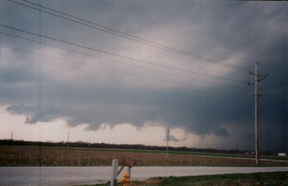
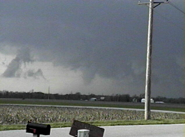
I drove up I-55 to the Litchfield exit, watching the cell come into view well to my west. About 10 minutes after I left home, the STL NWS office issued a severe t-storm warning for northern Jersey Co. for this cell. Movement was NE at 25, so it shouldn't be too hard to catch up and keep up with. There was also a smaller and weaker but strengthening cell closer to my SW, probably not too far from Edwardsville. By the time I neared Litchfield, the Jersey Co. storm was looking good - anvil being carried off far to the NE, and a hard, vertical tower at the storm's SW edge. I was a little north and well east of the updraft now, so I turned and headed west on IL route 16. By this time I had lost the STL weather radio station, so I put my AM radio on KMOX. A few miles west of Litchfield route 16 turns SW, but you can continue west by turning onto 1200 N. at Hornsby, which I did. I thought I could take that to route 4 and turn north toward Carlinville. As I got more west I tuned in the weather radio and got the STL station again, and found out that another tornado watch had been issued covering much of the remainder of southern Illinois not covered by the earlier one, including Macoupin Co. where I was located and points east. As I approached route 4 the storm was looking better and better, becoming more backsheared. When I got to hwy. 4, I decided to continue west rather than turning N., since the storm was still a ways to the west, with the updraft just a little farther south than my location. I was still facing bright sun as there was little or no flanking line or any other cloud structure to block it out. When I reached 1600E, which is a curving north-south road almost due S. of Carlinville, I decided to turn north. As I got closer to the storm, I got the first good look at its rain-free base, which contained some small lowerings. I continued north until I found a good place to stop about 4 or 5 miles S. of Carlinville. Going north I lost the weather radio station, so switched back to KMOX.
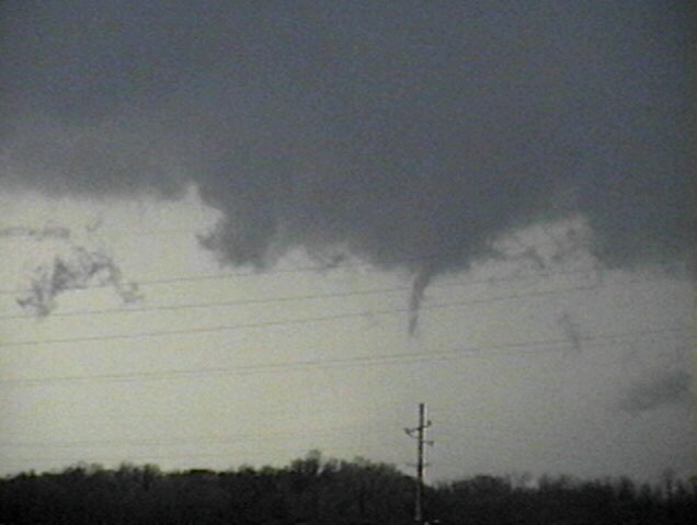
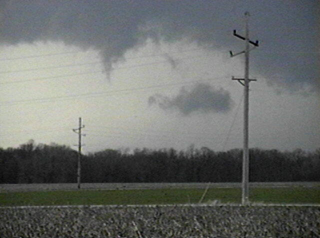
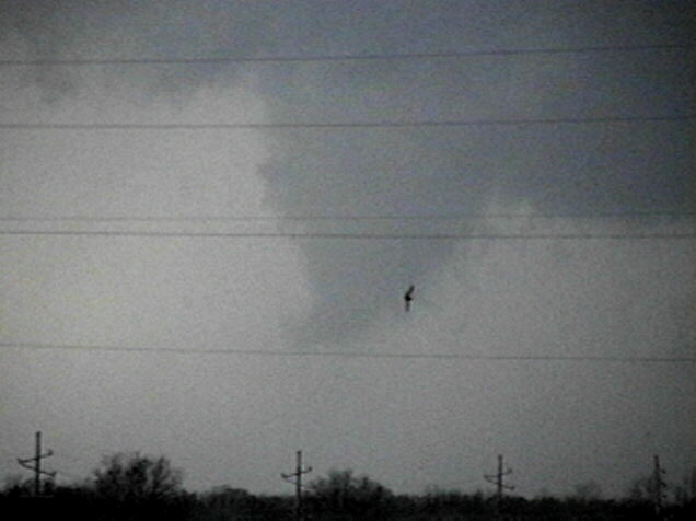
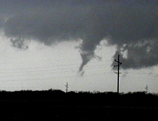
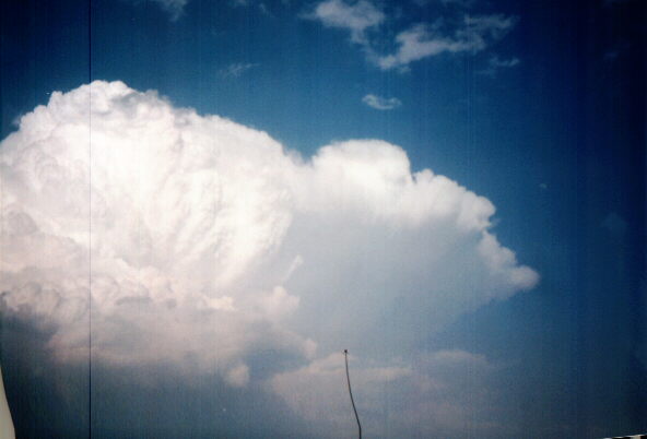
As I got out, I was blasted by inflow from the SE as I stood in awe of the spectacular storm structure before me - classic supercell structure. The anvil was now very backsheared, and towered above me. A wide wall cloud formed out of the lowerings under the main updraft, with inflow tails on both ends. CG lighting zapped down in the dense precipitation core to my north. I took photos and started to tape as some interesting lowerings extended from the wall cloud, only to realize after about 5 minutes that my camera was not taping - in my efforts to freeze the focus at the maximum distance, I had frozen the whole camera. I had to turn away from the awesome storm to deal with this bit of technological incompetence on my part, but after a few minutes finally solved the problem. With all the excitement I forgot to check the time, but it had to be around 4:20 or 4:25 when I arrived at that location. I watched, photographed, and videotaped the storm for 20 to 30 minutes. Toward the northern end of the wall cloud, I saw a needle funnel which persisted about 50 seconds. Here is a video snap of this structure just after it appeared, and here is another from about 30 seconds later. Toward the southern end of the wall cloud, some slow rotation became evident at the time of this shot. Toward its northern end, what appeard to be a much larger, wider funnel formed, though it was hard to tell for sure as this structure was slightly rain-wrapped. Here is another, more zoomed, video snap of this apparent funnel, with a possible slight RFD notch forming on the left. This lowering reached more than half of the way to the ground. Another narrow lowering formed near the southern end of the wall cloud; it reached almost 2/3 of the way to the ground. Its shape appeared to be that of a funnel but I could not verify rotation and it did have some discontinuities; after about one minute it appeared to rope out and disappeared. The whole time I watched this storm I was blasted by inflow from the SE that I would estimate at 20-40 mph - it is the main sound you can hear on my video. As more and more of the lowerings lost contrast as the storm got farther NE so the rain area was behind the lowerings, I knew it was time to move northeast.
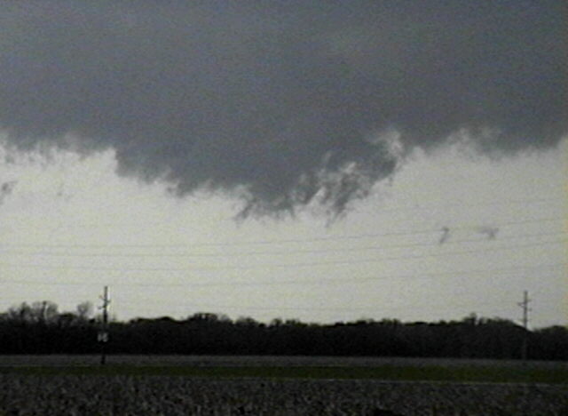
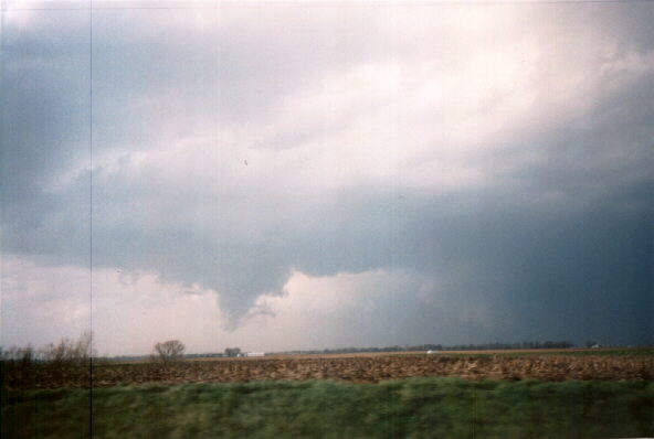
As I got in the car, KMOX was finishing up the process of announcing a tornado warning for Macoupin Co. - my storm! As the warning below indicates, St. Louis NWS had a TVS about 5 miles W. of Carlinville at 4:45 - the approximate location of the apparent large, partially rain- wrapped funnel I had seen. My only way northeast was to proceed into Carlinville and then head east, which I did, on IL route 108. Now the storm had gotten ahead of me and was both north and east of me - it seemed to be moving faster than before, which is confirmed by the NE at 35 movement indicated in the tornado warning. I figured I could head east then catch up with it by heading up I-55, but there was one problem with this - it was now about 5:00 and I was supposed to meet someone in Edwardsville at 5:30. I grabbed my cell phone and cancelled that. As I headed east, yet another lowering formed under the updraft which was now to my NNE. This may have been the most impressive of the day, a narrow lowering that reached 80 percent of the way to the ground. I could not verify rotation, so I would classify it as a "likely funnel" based on its appearance, but cannot say that with 100% certainty. In any case, it was every bit as awesome as it appears in the picture. I did not hear it at the time, but I found out later that, around this time, the Lincoln, IL NWS office issued a tornado warning for Southern Sangamon and northern Christian Co. based on a TVS around this general location. The lowering got shorter but wider, and to its right, too far away to see well, was what appeared to be a front-lit lowering extending almost to the ground. It appears as a lighter colored lowering on the right of the picture. However, given the rapidly increasing distance between me and the storm as it got farther and farther to the north of me, part of the latter formation could have been a sunlit rain or hail shaft. By now, I was in anvil rain from a rapidly intensifying storm to my SSW. Both to avoid getting hailed on by that storm and to try to catch up with the other one, I headed north on I-55. But the storm had too good a lead on me, so I gave up after two exits. By this time all the lowerings had disappeared, but the storm had developed what may have been an RFD notch. But seeing no more lowerings and being well-behind it, I gave up, as I was really needing to get home because of evening commitments.
As I headed back, the cell that had been to my SSW had crossed I-55 and was really intensifying. I got some nice pictures of it, and was fairly sure by looking at it that it had gone severe. Sure enough, when I checked the warnings archive later this evening, I found that it had prompted at least 2 tornado warnings. As I headed down I-55 for home, I pased through a couple convective, high-based rainshowers - really big drops spattering down in the second one. The cell to my east and the passing rainshowers resulted in several nice rainbows along the way home. I arrived home around 6:15; total chase distance about 125 miles.
Comments to John Farley, jfarley@siue.edu
BULLETIN - IMMEDIATE BROADCAST REQUESTED
TORNADO WATCH NUMBER 174
STORM PREDICTION CENTER NORMAN OK
344 PM CDT TUE APR 7 1998
THE STORM PREDICTION CENTER HAS ISSUED A
TORNADO WATCH FOR PORTIONS OF
CENTRAL AND SOUTHERN ILLINOIS
SOUTHWEST INDIANA
EFFECTIVE THIS TUESDAY AFTERNOON AND EVENING FROM 415 PM UNTIL 1000
PM CDT.
TORNADOES...HAIL TO 2 INCHES IN DIAMETER...THUNDERSTORM WIND GUSTS
TO 80 MPH...AND DANGEROUS LIGHTNING ARE POSSIBLE IN THESE AREAS.
THE TORNADO WATCH AREA IS ALONG AND 60 STATUTE MILES EITHER SIDE OF
A LINE FROM SCOTT AFB BELLEVILLE ILLINOIS TO 15 MILES SOUTH
SOUTHEAST OF BLOOMINGTON INDIANA.
REMEMBER...A TORNADO WATCH MEANS CONDITIONS ARE FAVORABLE FOR
TORNADOES AND SEVERE THUNDERSTORMS IN AND CLOSE TO THE WATCH AREA.
PERSONS IN THESE AREAS SHOULD BE ON THE LOOKOUT FOR THREATENING
WEATHER CONDITIONS AND LISTEN FOR LATER STATEMENTS AND POSSIBLE
WARNINGS.
OTHER WATCH INFORMATION... CONTINUE...WW 173...
DISCUSSION...AIRMASS NOW MODERATELY UNSTABLE S OF WARM FRONT ACROSS
IL INTO SWRN IN. WARM DEEPLY MIXED AIRMASS MOVING ACROSS EASTERN
MO WILL ENHANCE SEVERE THUNDERSTORM DEVELOPMENT ACROSS SRN IL.
VEERING WIND PROFILES WITH STRONG MID/UPPER JET FAVOR SUPERCELLS
AND ISOLATED TORNADOS.
AVIATION...TORNADOES AND A FEW SEVERE THUNDERSTORMS WITH HAIL
SURFACE AND ALOFT TO 2 INCHES. EXTREME TURBULENCE AND SURFACE WIND
GUSTS TO 70 KNOTS. A FEW CUMULONIMBI WITH MAXIMUM TOPS TO 500.
MEAN STORM MOTION VECTOR 24035.
...HALES
;392,0900 394,0864 380,0862 374,0894;
649
WWUS9 KMKC 071826
SEL3
MKC WW 071826
ILZ000-MOZ000-IAZ000-080100-
BULLETIN - IMMEDIATE BROADCAST REQUESTED
TORNADO WATCH NUMBER 173
STORM PREDICTION CENTER NORMAN OK
126 PM CDT TUE APR 7 1998
THE STORM PREDICTION CENTER HAS ISSUED A
TORNADO WATCH FOR PORTIONS OF
NORTHERN AND CENTRAL ILLINOIS
NORTHEAST MISSOURI
SOUTHEAST IOWA
EFFECTIVE THIS TUESDAY AFTERNOON AND EVENING FROM 200 PM UNTIL 800
PM CDT.
TORNADOES...HAIL TO 2 INCHES IN DIAMETER...THUNDERSTORM WIND GUSTS
TO 70 MPH...AND DANGEROUS LIGHTNING ARE POSSIBLE IN THESE AREAS.
THE TORNADO WATCH AREA IS ALONG AND 60 STATUTE MILES NORTH AND
SOUTH OF A LINE FROM 55 MILES WEST SOUTHWEST OF OTTUMWA IOWA TO 35
MILES EAST SOUTHEAST OF BLOOMINGTON ILLINOIS.
REMEMBER...A TORNADO WATCH MEANS CONDITIONS ARE FAVORABLE FOR
TORNADOES AND SEVERE THUNDERSTORMS IN AND CLOSE TO THE WATCH AREA.
PERSONS IN THESE AREAS SHOULD BE ON THE LOOKOUT FOR THREATENING
WEATHER CONDITIONS AND LISTEN FOR LATER STATEMENTS AND POSSIBLE
WARNINGS.
DISCUSSION... WARM FRONT LIFTING NWD THRU NRN MO/CNTRL IL AHEAD OF
APPROACHING MID LEVEL VORT MAX MOVING ENEWD FROM NWRN MO. AIRMASS
HAS CONTINUED TO HEAT AND DESTABILIZE SOUTH OF WARM FRONT...WITH
THUNDERSTORMS EXPECTED TO RAPIDLY DEVELOP EWD VICINITY OF FRONT
INTO IL. WIND SHEAR PROFILES FAVORABLE FOR SUPER CELLS AND
ISOLATED TORNADOES VICINTY FRONT WITH HELICITIES FROM 150 TO 200
J/KG VICINTY FRONT. COOL LAPSE RATES FAVOR STRONG POTENTIAL FOR
LARGE HAIL.
AVIATION...TORNADOES AND A FEW SEVERE THUNDERSTORMS WITH HAIL
SURFACE AND ALOFT TO 2 INCHES. EXTREME TURBULENCE AND SURFACE WIND
GUSTS TO 60 KNOTS. A FEW CUMULONIMBI WITH MAXIMUM TOPS TO 450.
MEAN STORM MOTION VECTOR 23030.
...HALES
;414,0932 410,0881 392,0881 395,0932;
807
WFUS1 KSTL 072145
TORSTL
ILC117-072230-
BULLETIN - EAS ACTIVATION REQUESTED
TORNADO WARNING
NATIONAL WEATHER SERVICE ST LOUIS MO
444 PM CDT TUE APR 7 1998
THE NATIONAL WEATHER SERVICE IN ST LOUIS HAS ISSUED A
TORNADO WARNING EFFECTIVE UNTIL 530 PM CDT
FOR PEOPLE IN THE FOLLOWING LOCATION...
IN CENTRAL ILLINOIS
...NORTHEASTERN MACOUPIN COUNTY
AT 444 PM...RADAR DETECTED A TORNADO 5 MILES WEST OF CARLINVILLE. IT WAS MOVING TO THE NORTHEAST AT 35 MPH. TOWNS IN THE PATH ARE NILWOOD...STANDARD CITY AND GIRARD.
THIS IS A DANGEROUS STORM SITUATION. ACT QUICKLY AND SEEK SHELTER NOW!
GKS/DM