|
"Before I built a wall I'd ask to know
What I was walling in or walling out, And to whom I was like to give offense, something there is that doesn't love a wall." |
|
Robert Frost
|
Machias Seal Island:
A Geopolitical Anomaly
-----------------------------------------------------------------
Table of Contents:
Abstract
Introduction
Boundary Review
International Definition of Sovereign
Acts of Interest - US
Acts of Interest - Canada
Lighthouse Arguments
Archipelago Arguments
Conclusion
Maps of Area
|
|
|
|
|
Introductiontop
The very definition of a "state" entails that it can't physically exist without a specific territory to control. Without the control of physical territory, a claim of political sovereignty is baseless politicking and worthless rhetoric. Therefore, it is imperative for a state to control territory so as to fulfill this basic definition of international law. This concept of independent sovereign control being the basis for a "state" has been a timeless cause of immeasurable strife with various ethnic groups, military strongmen, and political superpowers trying to claim their own part, or a bigger part, of the global pie.
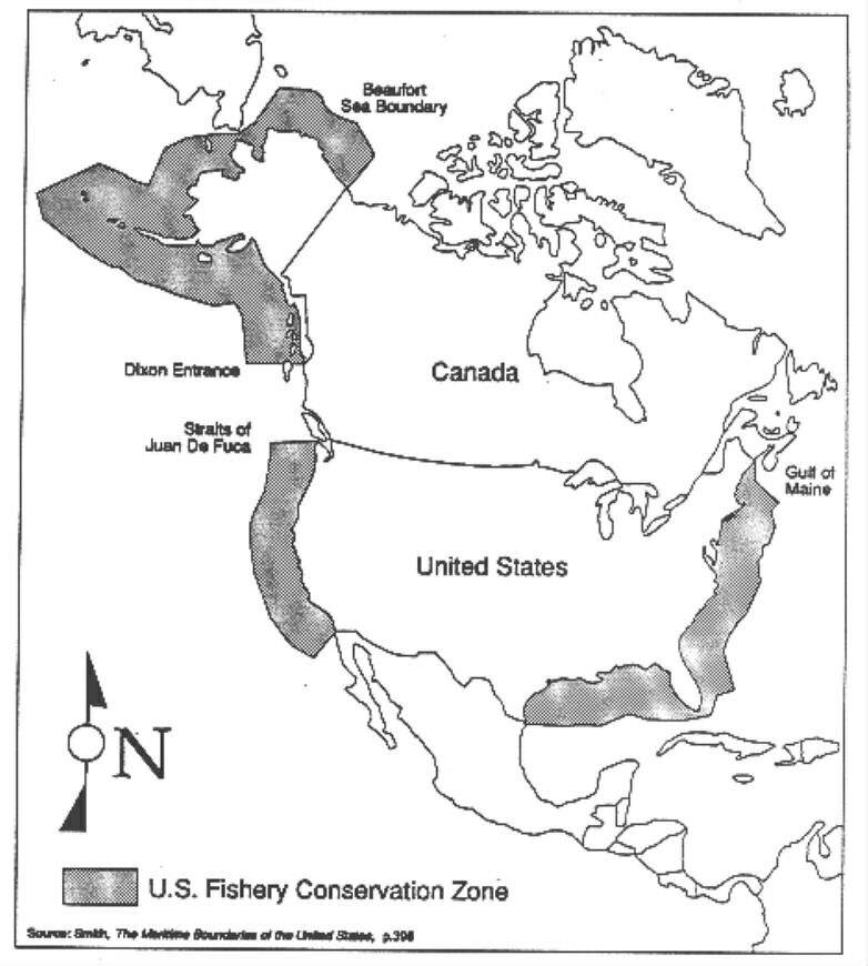
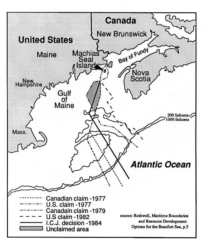
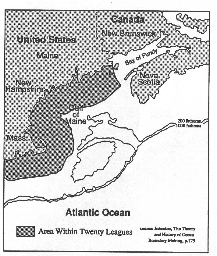
The United States itself has numerous boundary disputes over its territorial possessions with many countries around the world. Closer to home theand despite the amicable and co-operative political relationship between the US and Canada, all four of the shared oceanic boundaries are in some degree of contention. These boundaries dictate control over the rich fishing grounds and other natural resources of the continental shelf. The boundary through the Gulf of Maine at Machias Seal Island has never been officially defined, let alone delimited in any bilateral agreement due simply to the existence of this territory under dispute.This dispute actually could have been settled in the World Court's 1984 delimitation decision that divided up the rich fishing grounds on George's Bank.However, Machias Seal Island was deliberately left out of consideration because neither side was willing to have its interests invalidated. States are rarely willing to simply relinquish terra firma, even when no economic, political, or strategic benefit can be derived. Such acquiescence could obviously be viewed as weak and contrary to national interests by either the international community or constituents at home.Hence, Machias Seal Island is in the midst of a gap in the boundary line.
Both countries claim that the 1782 Treaty of Peace between Great Britain and the United States placed Machias Seal Island under their separate control. Both countries also claim that the policies and actions of their respective nations alone have fulfilled the legal precedents set in other international boundary disputes, and that both have manifested this sovereignty in several ways.Canada contends it has done this (1) through a lighthouse it built and has manned on the island since 1832; (2) through a position of "acquisitive prescription" resulting from the uncontested occupation of this lighthouse; (3) in its policing actions on and around the island.The U.S. contends (1) that international law dictates that the construction of a lighthouse does not entail manifestation of a nation's sovereignty over a specific territory, and (2) that it has acted sovereign through its own policing actions.
Because both countries feel resolute in these differing claims, neither party is willing to compromise in a settlement over the island. Luckily for both parties, there are no pressing issues that would force them to come to a resolution and potentially loose their claim of possession.
Boundary Reviewtop
The reason both nations claim the same 1782 Treaty of Peace left them Machias Seal Island is the result of the boundary description in the original land grant to Nova Scotia. The Treaty of Peace, ending the hostilities between the new United States and Great Britain, stipulated that the United States would have control over
"all islands within twenty leagues of any part of the shores of the United States,... excepting such islands as now are, or hereafter have been within the limits of the said province of Nova Scotia." (United States, Provisional Articles, p.55
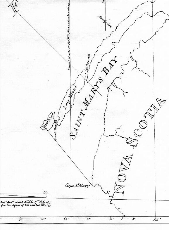
That said, the 1621 land grant deeding the Province of Nova Scotia to Sir William Alexander, reads that the boundary would encompass what is now known as Nova Scotia, from the eastern Atlantic side, around
"...to the west to the bay commonly called Saint mary's (sic) bay, thence to the North... crossing the entrance or mouth of (the Bay of Fundy),... to the river... Saint Croix." (Moore, Volume 1, p. 173-174)
It went on to further note that the province of Nova Scotia would include
"all the lands... with the rivers, torrents, bays, shores, islands, or seas lying near to, or within six leagues of any part ...of the said coasts." (Moore, Volume 1, p. 173-174)
The key stumbling block to whether the Machias Seal Island was included in the Province of Nova Scotia lies in the vague and imprecise wording of this grant itself, and is essentially two fold in nature. As illustrated earlier, either of two different boundary lines could be utilized to pivot the boundary one way or another in favor of that parties claim. This situation exists because the United States and Canada have never bilaterally agreed upon their own set of baselines.Baselines, straight lines drawn from point to point along an irregular coastline, are used to help delimit where a countries territorial waters should be defined. The other problem interpreting this grant lies in the term "near to," which appears with the six league limitation. This phrase is so vague and subjective that a quantitative definition is obviously indefinable. It can be easily argued that these two words alone have created the entire problem regarding the sovereignty over Machias Seal Island. Either side could claim that the island is or isnt "near to" the boundary, and so should or shouldnt be included as part of the claim.
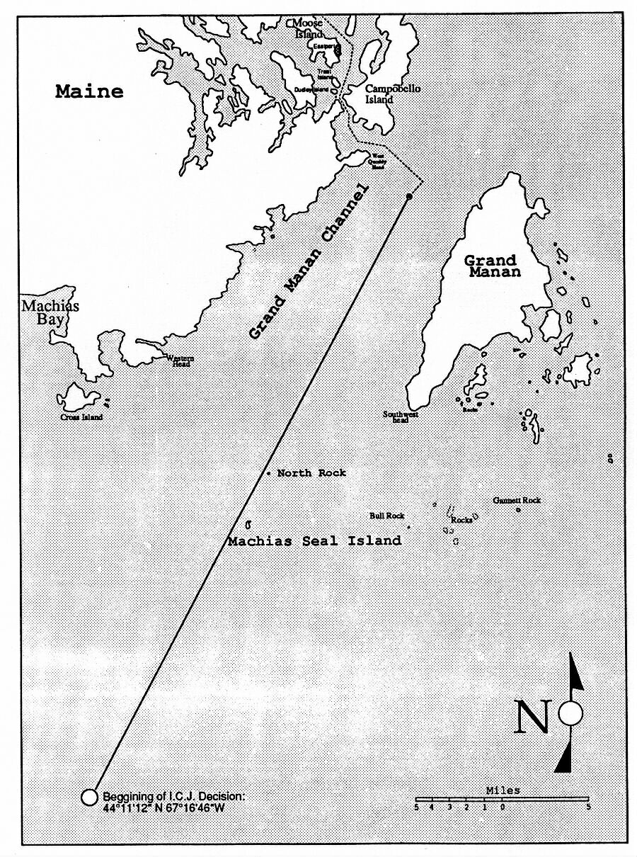
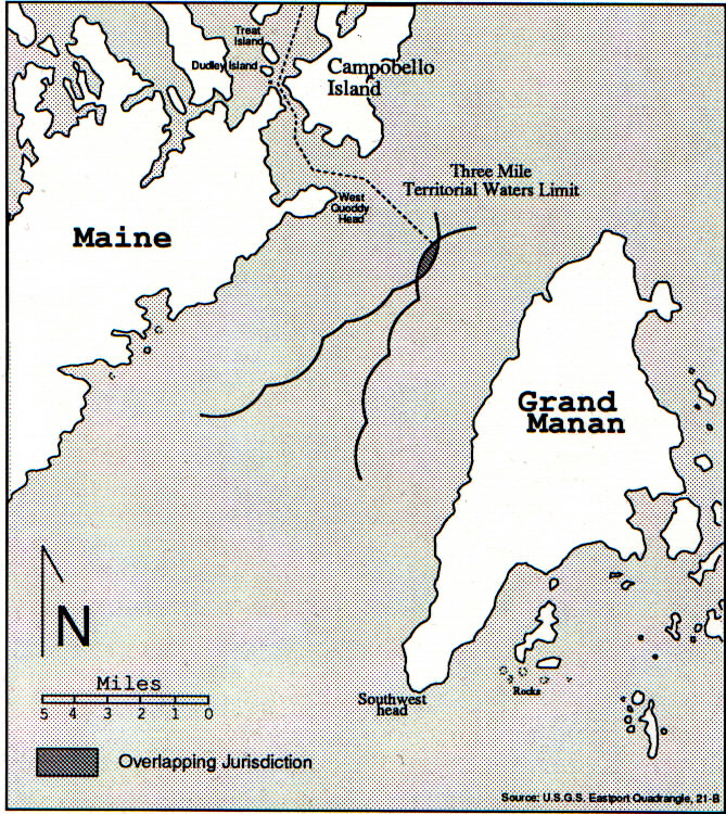
Regardless of its original inclusion in or exclusion from Nova Scotia, consequent treaties between the two countries have delimited the international boundary from the St. Croix River, out of Passamaquoddy Bay, into Grand Manan Channel, placing the endpoint within an area where the end of both countries three mile territorial waters ends.Sine the last treaty in 1925 was signed however, both countries have extended their territorial waters to the now international standard twelve miles, once again placing the island within the overlapping claims. As mentioned earlier, due to this specific dispute the boundary actually could have been settled in the World Court's 1984 Georges Bank delimitation decision.Machias Seal Island is now in the midst of a gap in the nautical boundary between the two countries, a rather unique situation indeed.
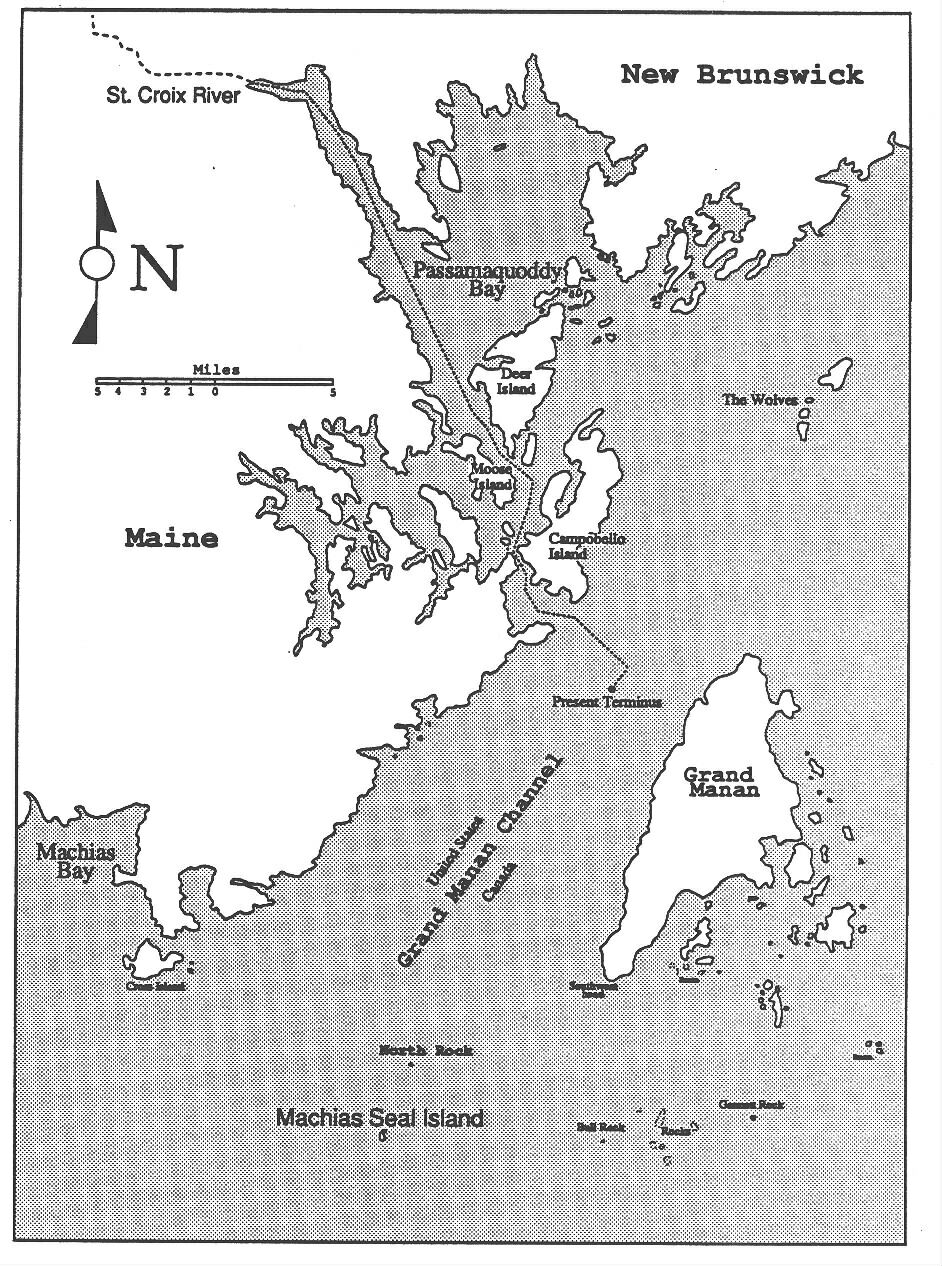
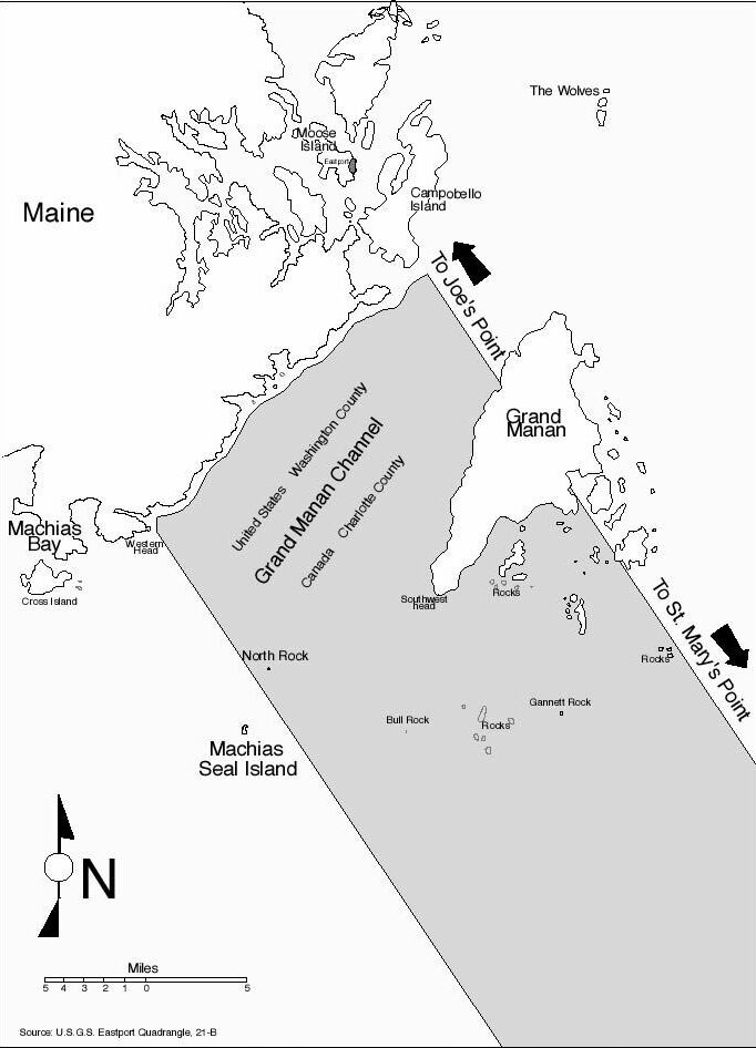
Canada asserts it gained ownership through this early grant because a line drawn from Whipple Point, on Briar Island (which encloses St. Mary's Bay) to Joe's Point, in Passamaquoddy Bay, would include Machias Seal Island within the six league clause. The United States likewise believes that it gained ownership over Machias Seal Island because a line drawn from Cape St. Mary's, Nova Scotia to Joe's Point, New Brunswick would just barely exclude the island from the six league clause. Because it is excluded from Nova Scotia it would therefore belong to the United States because of the twenty leagues clause, noted earlier, in the Treaty of Peace. It should be noted that early arguments of the United States actually tried to use the mainland terminus of the western arm of St. Mary's Bay as the start of the boundary line across the Bay of Fundy as can be seen on the original submission, and ignore the logical end of St. Mary's Bay at the end of the large islands that clearly contain the Bay's west shore for another twelve miles.
International
Definition of Sovereigntytop
For either country to claim sovereignty over Machias Seal Island they would have to fulfill the basic description of sovereignty as prescribed by international law. There are essentially two recognized methods that are viewed as valid for acquiring territory. One relies on a title, the other on occupation.
Acquisition with Title
The concept of ownership via a title versus ownership based on occupation was addressed in the Island of Palmas Case. In his remarks about sovereignty in its relation to territory the presiding judge made this statement.
"If
a dispute arises as to the sovereignty over a portion of territory, it
is customary to examine which of the States claiming sovereignty possesses
a title, cession, conquest, occupation, etc.,- superior to that which the
other state might bring forward against it." (Scott, p. 92)
"...there should be applied to territorial question the principle that,
failing any specific provision of the law to the contrary, a jus in re
once lawfully acquired shall prevail over de facto possession however well
established." (Scott, p. 94)
This passage illustrates the concept that one party must recognize the authority of a previous acquisition and title despite an apparent lack of attention paid to it in developing the area. For example, if a person were to leave their summer cottage and return the following year to find it occupied by squatters, the owner would obviously have the right to force them to leave.Once a territory is formally acquired, even if ceded by the losing party in a war, the territory belongs to the owner.If the sovereign party does not use, populate, or develop the territory is of no consequence.
This passage also notes several criteria one nation may have over the other, listing claims of "possessing a title, cession, conquest, occupation." Again though, since no side possesses a clear title over it, neither side has granted any cession to it, and nobody has set out to "conquest" the island, any judgments will have to come from other elements, such as an occupation or, as noted before, that have illustrated "the intention and will to act as sovereign, and some actual exercise of display of such authority."
Acquisition without Title
On the other hand, Acquisition without title is a much trickier proposition. The World Court noted in the Clipperton Island Case that the possession of control and spirit of occupation
"consists in the act, or series of acts, by which the occupying state reduces to its possession the territory in question and takes steps to exercise exclusive authority there." (McDougal Riesman, p.627)
In The Legal Status of Eastern Greenland case, the World Court said that for a state to claim
"sovereignty based not upon some particular act of title such as a treaty of cession but merely upon the continued display of authority involves two elements each of which must be shown to exist; the intention and will to act as sovereign, and some actual exercise of display of such authority." (McDougal Riesman, p.629)
Similarly,the islands in the English Channel of Minquiers and Echros were once debated as well with the presiding judge elaborating on two points that led him to his conclusion. First, he took into account the natural unity of the Channel Islands archipelago, and secondly, "the continuous and keen interest shown by England" and a much less lively and assiduous interest shown by France." This keen interest by the British went so far as to exercise local administration, legislation, and in the levying of taxes on the islets. (United Nations, Minquiers and Echros Case, p667-668)
These passages illustrate that a state cannot just claim ownership if they do not hold a clear title, but must actively take steps to show that it is indeed in control of a piece of territory. Otherwise, one would have no choice but agree that the entire western hemisphere would belong to England via Cabot's 1497 landings on the North American continent.
A claim of ownership, if not based on the Nova Scotia land grant itself, could also borrow from the concept of acquisitive prescription, or squatter's rights. International law says that prescription may be defined as "the acquisition of sovereignty over a territory through contiguous and undisturbed exercise of sovereignty over it, during such a period as is necessary under the influence of historical development the general condition of things is in conformity with international order." (1 Oppenheim,International Law 576 (8th ed. Lauterpacht, (1955)) as cited by Baxter/ Horwitz,Opinion is Support...,p.13) This essentially says that if something lies unattended, the person who picks it up and uses it enough to make people think it always was theirs is the new owner.
Since no side possesses a clear title over the island, neither side has granted any cession to it and nobody has set out to "conquest" the island, any judgments of ownership will have to come from other methods of determination. There have been similar cases in other international boundary/ territorial disputes that have been ruled on by the World Court.These cases have used things such as an occupation of a territory, or an interest that has illustrated the intention and will to act as sovereign, and some actual exercise of display of such authority as a means of determining who is in control ofa territory.
Acts of Interest - UStop
If the United States did establish valid control through the Treaty of Paris, it would not need to do anything to re-establish its claim. As long as the United States does not compromise its rights through inattentiveness or passive dormancy, it would not need to actively pursue as "interest" in the island, but only to continually reaffirm its sovereignty whenever a foreign claim is made against it. The US feels that by not acknowledging that a claim has any basis it has effectively kept any rights from arising due to its acquiescence. To effectively demonstrate its "continual display " of authority, the State Department has issued statements to boat operators and fishermen reaffirming United States sovereignty over the island and bestowing upon them the "right" not to comply with any foreign laws or regulation in relation to this dispute. Fishermen on both sides of the line have had issues with the Coast Guard telling them they are in foreign waters and confiscating lobster traps etc. Another issue has been the Canadian Wildlife Service enforcing regulations on the number of people that can land on the island to go bird watching, a growing business in recent years and one of the major sources of friction involving the island.
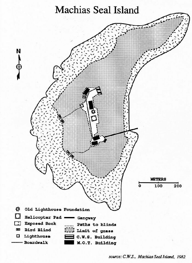
As far as other acts of interest go, there are reports of US soldiers being stationed on it during WWII.It should be noted though that this was supposedly done to aid the Canadian war effort. Another notable act of U.S. interest has been manifested through a group of citizens who call themselves the "Government of the Territory of Machias Seal Island, U.S.A." and consider the island to be an unincorporated island within United States Territory. Every year they motor out to the island, plant the US flag, and hold a meeting to demonstrate US control over and interest in the island. The island is noted as #79367 in the Coastal Island Registry, yet the State of Maine considers the island to be federal property and not its responsibility. However, until very recently the island was not even included on USGS maps. Although USGS maps are not in any way legal documents concerning the legal boundaries and territories controlled by the United States, it would seem logical to assume that if there was any "interest" in Machias Seal Island the island would have been included in the map set. It was once included on the 1915 Cutler Maine quadrangle, but was left off subsequent editions and only recently was re-introduced to the USGS series.The only official document in the Maine Government concerning Machias Seal Island lies in the Coastal Island Registry, where it is listed as #79-367. However, a 1975 investigative report obtained from the Registry states that the Island is believed to be "in Canada." Nearly all local sources in Maine, note that the island is controlled by Canada, and more specifically the Canadian Wildlife Service, which controls the number of visitors that are allowed to land on the island. Publicly, Canada is very visibly in control over the island it would appear.
Acts of Interest - Canadian top
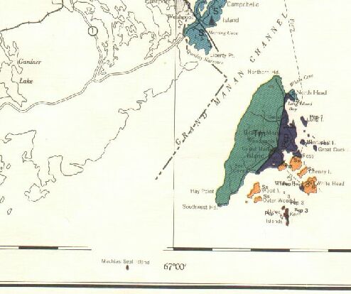
Being that Machias Seal Island lies nearly directly in the shipping lanes leading into Passamaquoddy Bay, the only shipping access for New Brunswick, Canada has indeed had quite an interest in Machias Seal Island. In 1832, Canada built a lighthouse to aid shipping navigation. In 1912 the Canadian Dept. of Transportation filed a claim over the island with the tax assessors office in New Brunswick, concerning the lighthouse it had built and also sub-surface mineral rights claims with the Department of Natural Resources. In 1956, 1976, and 1980 a group of Grand Manan, New Brunswick residents filed a mining claim with the New Brunswick Dept. of Natural Resources, specifically stating they wished to display and exercise Canadian authority. The lighthouse is also included in the Seal Cove polling district to allow lighthouse keepers to vote in local and federal elections. The Canadian government has actively sought to include it on all its maps to indicate its high level of interest. At times they have gone so far as to actually remove the map borders so that it could be displayed, and to recenter maps of the area so it was included on them.
Lighthouse Arguments top
These "acts of interest" taken by Canada, unmatched by any U.S. agency, parallel the actions taken by the British in the previously mentioned Minquiers and Echros Case.In what is easily the biggest and most tactile action that has indicated an interest in Machias Seal Island, the Canadian government erected a lighthouse to help aid in navigation around Machias Seal Island in the Grand Manan Channel. Although seemingly a solid indicator of sovereign control, this action does not qualify alone as an indicator of sovereignty.The issue concerning whether the erection of a navigational aid is grounds to establish sovereignty over an island, has been argued before in international law, and lost. The Taganak Island Lighthouse Dispute, The Red Sea Lights Agreement, The Cape Spartal Lighthouse Case, and The Minquiers and Echros Case all support the opinion that the erection of a lighthouse does not preclude a claim of sovereignty over an island.
In the previously mentioned Minquiers and Echros Case, an ownership dispute involving these islands was brought before the International Court of Justice. The erection of lights and buoys on these islands by France was the main argument in France's claim of ownership.Similar to the treaties concerning the United States/ Canada boundary, none of the treaties between the United Kingdom and France specified which islands either party held. These small islands, of minimal importance, were not mentioned in any previous treaty. The judges decision noted that although France had "assumed sole charge of lighting and buoying... without encountering any objection from the United Kingdom," this fact was irrelevant. Great Britain claimed that the public utility of the buoys and lights did not infringe on British shipping interests, and so did not object to their positioning. (United Nations, Minquiers and Echros Case, p. 666)
Apparently the court agreed with Great Britain as it stated that since the buoys were placed outside the reefs, and were therefore intended for aiding navigation and to protect shipping, they were not a manifestation of French sovereignty over the Minquiers and Echros Islands. One item of difference here though is that the Canadian government erected a lighthouse on the island, which is different than just maintaining buoy's on the reefs off an island as did France. However, since the United States was not prejudiced by the public utility of placing a lighthouse on the island, it would follow that Canada can't use this argument as a basis for its claim of ownership. However, in an interesting side note, the United States used this very same argument in its deliberations over the larger Georges Bank decision of 1984, claiming it had been responsible for the maintenance of navigational aids in the area
Archipelago Arguments top
In the previously mentioned Minquiers and Echros Case, the presiding judge took note of the natural unity of the Channel Islands archipelago and concluded that the archipelago, with its natural unity, were undoubtedly English. (United Nations, Minquiers and Echros Case, p. 668) Although it could be argued here that Machias Seal Island is part of the archipelago surrounding Grand Manan, the very definition of an archipelago adds more factors to consider than just proximity.
The Law of the Sea states that an archipelago is: "a group of islands, including parts of islands, interconnecting waters and other natural features which are so closely interrelated that such islands, waters and other natural features form an intrinsic geographical, economic and political entity, or which historically have been regarded as such." (United Nations, Law of the Sea, Volume IV, Article 46b - emphasis added)
Geographically speaking, a quick look at the maps show that there is certainly an archipelago in the southern waters off of Grand Manan which is not disputed to belong to Canada. While bathymetrically Machias Seal Island is separated from the US mainland by a wide channel that is deeper than the channel separating it from the Grand Manan archipelago, the bedrock is composed of rock of the island that is more akin to the rock on the US mainland than Canada. Its minimal economic value is roughly of equal value to both countries as a bird watching tourist destination.The political interests and actions have been previously outlined.Finally, historically the Canadian government does seem to have an advantage as locals acknowledge that Canadian officials have been the defacto law on the island. However, no matter whether the island was construed to be part of the Grand Manan archipelago, the international boundary would obviously outweigh this argument.
Conclusiontop
In regards to Machias Seal Island's ownership, the United States is relying on its interpretation of the wording in the original Nova Scotia grant and subsequent treaties to assert its ownership over the island. The fact it has not taken other active steps to indicate or assert its "interest" shows the governments firm belief in the strength of its argument. Canada also believes in the strength of its interpretation of the same treaty but has also taken numerous additional steps to show an "interest" in the island.
However, relying on treaty interpretation to determine the original boundary of Nova Scotia, and hence Machias Seal Island, is an inconclusive method due primarily to the imprecise and vague nature of the wording in the treaty. The only remaining valid method for ascertaining the ownership of Machias Seal Island lies in showing which country has shown a greater amount of "interest" in the island as International Law dictates should be the criteria. As it stands now, both countries have too much "face" at stake, and the island is of small enough importance, to resolve the situation as effectively as they could.It can be seen though, that with the evidence demonstrated by both parties involved, Canada has been much more astute in creating the impression that it is sovereign over Machias Seal Island.Luckily, since the island is so unimportant, both countries have no problem in simply letting sleeping dogs lie. Warships will probably not be steaming into the Bay of Fundy any time soon.
Bibliography
Allaby, Eric. Telephone Interview. Grand Manan Historian. 17 February 1991
Amarantes, James P. "Affidavit." 26 Aug. 1985. New Brunswick Department of Natural Resources. file: Machias Seal Island. doc. number 68505000.
Anderson. William. Plan and description of certain lands taken for the use of His Majesty the King to be used as the Public Work known as 'Machias Seal Island lighthouse', 14 May 1912. Chief Engineers Office. Department of Marine and Fisheries. Ottawa; Canada. file # 29278.
Baxter, Richard R. and Horwitz, Morton J. Opinion In Support of the Sovereignty ofthe United States of America over Machias Seal Island and North Rock. Submitted to the Marine Resources Commission, State of Maine. Cambridge, Massachusetts. 16 Jan. 1975.
---. A Short History of the Lighthouses on Machias Seal Island. Submitted to the Marine Resources Commission. State of Maine. Cambridge, Massachusetts. 16 Jan. 1975.
Beal, Clayton. "Jonesport Captain Continues One Man Crusade For U.S. Sovereignty On Machias Seal Island." Bangor Daily News. 17 June 1987. Down East Ed.: 9
Blake, Gerald et.al. Maritime Boundaries and Ocean Resources. International Geographical Union Study Group on the World Political Map. New Jersey. 1987.
Bouchette, Joseph. The British Dominions in North America. London: England. v.1. 1832.
---. Topographic Description of the Province of Lower Canada. London: England. 1815.
Burnett, James A. "Birds Know No Boundaries." Canadian Geographical Journal. 10-11/1990. pp.32-38. 1990.
Brierly, J.L. The Law of Nations. Oxford: Clarendon Press. 1955.
Canada. "An Act to amend the Territorial Sea and Fishing Zones Act." Statutes of Canada. 26 June 1970. 18-19 Elizabeth II. Chap. 68.
---. Machias Seal Island. Department of External Affairs. public press release. 1991
---. "Order in Council #1971-366." Privy Council. 25 Feb. 1971.
---. "Order in Council #2678." Privy Council.
---. "Territorial Sea and Fishing Zone Act." Statutes of Canada. 16 July 1964. 13-14 Elizabeth II. Chap. 22.
---. "Territorial Sea and Fishing Zones Act." Revised Statutes of Canada 1985. 8:T-8. 1985.
---. "Territorial Sea and Fishing Zones Act." Canada Gazette, Part II 105:364. SOR/ 71-81. 25 Feb. 1971.
Canadian Hydrographic Service, Dept of Fisheries and Oceans. Sailing Directions-Nova Scotia and Bay of Fundy. Hull: Canada 1985.
Canadian Wildlife Service. Machias Seal Island. Pamphlet. 1982.
---. Migratory Bird Permit. Issued to Captain Barna and John Norton. 1989.
---. Visitor Statistics for Machias Seal Island. 1973-1990.
Chadbourne, Ava Harriet. Maine Place Names and the Peopling of Its Towns. Bangor: Maine. 1955.
Connolly, Maureen. "U.S., Canada Argue Over Seal Island" Daily Kennebec Journal. n.p. 7 Aug. 1974.
Colson, David A. "U.S.-Canada Maritime Boundary Disputes: Why aren't they solved?" speech delivered to the Canadian Council on International Law. Ottawa. 17 Oct. 1987.
Colson, David A. Personal Interview. United States State Department. 21 Nov. 1990.
Cooper, John. "Delimitation of the Maritime Boundary in the Gulf of Maine Area." Ocean Development and International Law. 16:59. 1986.
Crandall, Esther. "Rember Machias Seal Island?" The Atlantic Advocate. June 1974: 47-53.
Cukwurah, A. O. The Settlement of Boundary Disputes in InternationalLaw. New York: Oceana Publications. 1967.
deBlij, Harm J. "The U.S. and its Maritime Neighbors." Focus. Fall 1986: 30-31.
deBlij, Harm J. and Glassner, Martin I. Systematic Political Geography. Fourth ed. New York: John Wiley & Sons, Inc. 1967.
Doiron, Robert. Telephone Interview. Maritime Resource Management Service. 29 Jan. 1991.
Freeman, Allan. "Where Puffins Go To Nest, U.S. and Canada Quarrel Wall Street Journal. 31 Aug. 1984: 16.
Gettle, Tom. Telephove Interview. U.S. Fish and Wildlife Service 25 Feb. 1991.
Gluek, Alvin C. Jr. "The Passamaquoddy Bay Treaty, A Diplomatic Sideshow in Canadian-American Relations." Canadian Historical Review. V47:1-21. March 1966.
Hamilton, William B. The Macmillan Book of Canadian Place Names. Macmillan: Toronto. 1978.
Ireland, Gordon. Boundaries, Possessions, and Conflicts in Central and North America and the Carribean.. Cambridge: Mass. 1971.
Jhabvala, Farrokh. Maritime issues in the Caribbean. Miami: University Presses of Florida. 1983.
Johnston, Douglas M. The Theory and History of Ocean Boundary-Making. Montreal: Canada. Mcgill-Queen's University Press. 1988.
Johnston, Douglas M. and Saunders, Phillip M. et.al. Ocean Boundary Making: Regional Issues and Developments. New York: Croon Helm. 1988.
Journals of the House Assembly of New Brunswick, 1842, at
46. cited by Baxter/ Horwitz, A short History...
p.4
Kannegieser, Jeanne. Telephone Interview. Maine
Coastal Islands Registry. 5 Dec. 1990.
Kilby, William H. Eastport and Passamaquoddy. Eastport:
Maine. Edward E. Shead & Company. 1888.
Kelley, Don. Telephone Interview. U.S.G.S.
10 Oct. 1989.
Line, Les. "Puffins Without a Country" National Wildlife. 3 Feb. 1973: 37-38.
McClain, Charles. Telephone Interview. Canadian Board on Geographic Names. 7 Jan. 1991.
Maine Coastal Island Registry. Coastal Island Resource Investigation: Island Discrepancies. File: number 79-367. 16 August 1975
Maine Times. "Canadian Claims Machias Seal Island," 10 Sept. 76: 7.
---. "Canada Wants Machias Seal Island." 18 March 1977: 27.
---. "Machias Seal." 20 Aug. 76: 20-21.
Manuscript of Argument Before Commissioners Under Article IV of Treaty of Ghent. State Dept. Archives. as cited by Baxter and Horwitz in Opinion In Support ..., p.2.
McDougal, Myres S. and Reisman, W.M. International Law in Contemporary Perspective. Mineola, New York: Foundation Press Inc. 1981.
McEwen, Alec. "Machias Seal Update: An Update". Atlantic Advocate. Aug. 1985: 52-53.
Moore, John Bassett. International Adjunctions, Modern Series. 2 vols.. New York: Oxford Univ. Press. 1929.
Morganthau, Tom and Wang, Penelope. "The Seal Island Face Off." Newsweek. 23 July 1984: 49.
Morrison, Joel. letter to author. United States Geological Survey. 26 Feb. 1990.
Nicholson, Norman. Boundaries of Canada. Canadian Dept. of Mines-Geographic Branch. 1954.
Orth, Donald J. United States Board on Geographic Names. letter to Alec C. McEwen. 9 Dec. 1987.
Paquette, Noel. Telephone Interview. International Boundary Commission. 31 Jan. 1991.
Petition of the Chamber of Commerce of St. Andrews. Jan. 29, 1831. Provincial Archives of New Brunswick. Records of the Executive Council: Lighthouses. as cited by Baxter/ Horwitz. A Short History..., p.1. 1975.
Pettingill, Sewill. "Bird Finding With Sewall Pettingell" Audubon Magazine. May-June 1959: 128-129.
Porter, Norman , telephone interview, Canadian Department of Transportation. 28 January 1991
Prescott, J.R.V. Political Boundaries and Frontiers. Boston: Allen & Unwin. 1987.
---. The Political Geography of the Oceans. London: David & Charles. 1975.
Rayburn, Alan. Geographical Names of New Brunswick. Ottawa: Ontario. 1975.
Randall, T. Maritime Claims Reference Manual. Asst. Sect. of Defense. Washington D.C.. June 1987.
Report of the Commissioners of Campobello Light House on the subject of erecting a Lighthouse on Machias or West Seal Islands in the Bay of Fundy, June 30, 1831, Provincial Archives of New Brunswick. Records of the Executive Council: Lighthouses. as cited by Baxter/ Horwitz, A Short History..., p.1. 1975.
Ricketts, Peter. "On the Geography of Maritime Boundary Disputes." The Operational Geographer. V6 1985:22-26.
Romig, Edgar. Reverend. Epiphanies Remembered. Church of the Epiphany. Washington , D.C.. sermon #1418. 7 Jan. 1990.
Rothwell, Donald R. Maritime Boundaries and Resource Development: Options for the Beaufort Sea. The Canadian Institute of Resources Law. June 1988.
Rutherford, Phillip. The Dictionary of Maine Place Names. Freeport: Maine. 1970.
Scott, James B. ed. Hague Court Reports (second series). New York: Oxford University Press. 1932.
Shewmaker, Kenneth E.. et. al. The Papers of Daniel Webster Diplomatic Papers, Volume 1 1841-1843. Hanover: University Press of New England. 1983.
Smith, Al. Telephone Interview. Canadian Wildlife Service. 28 Jan. 1991.
Smith, Robert. "The Maritime Boundaries of the United States." Geographic Review. Oct. 1981. pp. 395-410.
Thurston, Harry. "Machias Seal Island." Equinox. 7-8/1990. pp.91-97.
Toronto Star. "We Could Trade an Island for a Point." 12 Aug. 1976.
United Nations. The Law of the Sea. New York: United Nations. 1983.
---. "The Minquiers and Echros Case (France vs. the United Kingdom)"
Yearbook of the United Nations 1953. 1953 :663-668. New
York: United Nations. 1953.
---. The Law of the Sea: Maritime Boundary Agreements, 1970-1984.
Office for Ocean Affairs and the Law of the Sea. New York:
United Nations. 1987.
---. "Maritime Boundary Delimitation Between Canada and the United States." Yearbook of the United Nations 1981. 35:1202. New York: United Nations. 1985.
---. "Maritime Boundary Delimitation Between Canada and the United States." Yearbook of the United Nations 1982. 36:1367. New York: United Nations. 1986.
---. "Maritime boundary delimitation between Canada and the United States." Yearbook of the United Nations 1983. 37:1103. New York: United Nations. 1986.
United States. "Maritime boundary delimitation between Canada and the United States." Yearbook of the United Nations 1984. 38:1048. New York: United Nations. 1987.
---. "An Act For Establishment of the Waterton-Glacier International Peace Park." United States Statutes At Large. 47 pt.1:145. 2 May 1932.
---. "A Treaty." United States Statutes At Large. 8:572-577. 19 Aug. 1842.
---. "A Proclamation." United States Statutes At Large. 27:115-116. 22 July 1892.
---. "A Proclamation." United States Statutes At Large. 39 part 2:1702-1705. 16 Aug. 1916.
---. "Boundary Convention-Great Britain." United States Statutes At Large. 35:2003-2014. 11 April 1908.
---. "Boundary Treaty-Great Britain." United States Statutes At Large. 36:2477-2480. 21 May 1910.
---. "Boundary Treaty-Great Britain-Canada." United States Statutes At Large. 44 pt.3:2102-2107. 24 Feb. 1925.
---. "Decision." United States Statutes At Large. 8:250. 24 Nov. 1817.
---. "Declaration." United States Statutes At Large. 8:251. 17 Nov. 1817.
---. "Definitive Treaty With Great Britian." United States Statutes At Large. 8:80-83. 3 Sept. 1783.
---. "Exclusive Economic Zone of the United States of America." Federal Register. V48 pt. 9:10605-10606. Proclamation #5030. 14 March 1983.
---. "Explanatory Article." United States Statutes At large. 8:131-132. 15 March 1798.
---. "Fishery Conservation Zone." Public Notice #526. Federal Register. 42:12937-12940. 7 March 1977.
United States. "Maritime Boundaries." Public Notice #506. Federal Register. 41:48619-48620. 4 Nov. 1976.
---. "Maritime Boundary: Dispute Settlement." Canada. Treaties and Other International Acts Series. #10204. signed 29 May 1979; in force 20 Nov. 1981.
---. "Provisional Articles." United States Statutes At Large. 8:54-57. 30 Nov. 1782.
---. "Roosevelt Campobello International Park." Canada.
Treaties and Other International Acts Series. #5631. signed 22 Jan.
1964; in force 14 Aug. 1964.
---. "Territorial Sea of the United States of America."
Proclamation #5928. Federal Register 54 pt 1:777. 27 Dec. 1988.
---. "Treaty of Amity, Commerce and Navigation." United States Statutes At Large. 8:116-129. 19 Nov. 1794.
---. "Treaty of Peace and Amity." United States Statutes At Large. 8:218-223. 24 Dec. 1814.
---. "Tariff Act of 1930." United States Statutes At Large. 46 pt.2:590-763. 17 June 1930.
United States. Department of State. "Expanded Canadian Maritime Boundary Claim." State Department Bulletin. V78: 43. Dec. 1978.
---. ---. "Maritime Boundaries Between the U.S. and Canada." State Department Bulletin. V75: 667. 29 Nov. 1976.
---. ---. "Maritime Boundary and Resource Agreements." State Department Bulletin. V79:7-9 June 1979.
---. ---. "U.S. Regrets Canada's Extersion of High Seas Jurisdiction." State Department Bulletin. V64:139. 1 Feb. 1971.
---. ---. "U.S. Submits plea to I.C.J. Concerning Canadian Maritime Boundary." State Department Bulletin. 83:58. Aug. 1983.
VanderZwaag, David L. The Fish Feud: The U.S. and Canadian Boundary Dispute. Lexington: Lexington Books. 1983
Van de Poll, Henk W. Telephone Interview. University of New Brunswick, Canada. 11 Oct. 1989
Ward, Kent. "U.S.-Canada split over tiny island? Christian Science Monitor. 1 Oct. 1976. p.15
Weber, Tom. "The Captain's Crusade." Bangor Daily News. Style Section. p.1&12. 16 July 1988
Whitaker, John C. "Machias Seal Island: A Continuing Dispute The Atlantic Advocate. June 1979. pp.50-52.
Whittman, Jack. Telephone Interview. United States
Geological Survey. 12 Dec. 1991 and 19 Feb. 1991.