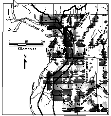
 Figure: Locations of GLO Survey Witness Trees in Madison
and St. Clair Counties in Southwestern Illinois
Figure: Locations of GLO Survey Witness Trees in Madison
and St. Clair Counties in Southwestern Illinois
Figure: Locations of GLO Survey Witness Trees in Madison
and St. Clair Counties in Southwestern Illinois
Presettlement tree distributions, from two Southwestern Illinois counties were compared with physiographic regions using maps created on MAPINFO, a Geographic Information System. The ecotone between the forests of the Mississippi Borderland bluffs and the Illinoisan Till Plains is clearly shown on the GIS maps. The ecotone follows a creek valley that divides the sharply dissected bluffs from the flat till plains. Fire intolerant taxa such as Ulmus spp., Celtis spp., Populus deltoides, Acer negundo, and Fraxinus spp. grew in the complex of wetlands nearest to the Mississippi River. The bluffs along the river had a moderately fire tolerant forest of Quercus alba, Q. velutina/ Q. rubra, and Carya spp. The Illinoisan-aged till plains of the eastern part of the study area supported a mixture of prairie, Quercus palustris, and Q. stellata on soils that were occasionally waterlogged. Keywords: Illinois, Public Land Survey, pre-settlement vegetation, Prairie Peninsula, Oak-Hickory Forest