
I proceeded southwest on I-44, stopped for a short data check at Flying J in Joplin, then proceeded on to Vinita where my plan was to cut west to Bartlesville on route 60 to see what would develop. By the time I reached Vinita, convection had broken out west of Bartlesville, and I was on track to intercept the storms (which were mostly elevated, but I thought they could intensify and become more surface-based with time) near Bartlesville around 1:30. That is, until I unknowingly made a wrong turn on the edge of Vinita and made it almost to Claremore before figuring out I was going southwest on 66, not west on 60! Arrgghhh! Second time I have missed a turn and gone well out of my way this season! This blunder cost me an hour, and by the time I got to Bartlesville, the storms were moving well north of there and clearly were not going to be severe. All the buzz on the weather radio now was about storms coming off the dryline, and sure enough when I managed a wireless internet data check at a Bartlesville motel, a red box was out for central OK, more or less centered on OKC and extending northward to around Stillwater. I decided to book west on 60 (which I managed to stay on this time) through Ponca City and headed south on I-35.
As I headed south, I became more and more aware of storms to my west. Approaching Perry, I could see the tail end storm to my SW and could not see any further storms off to the SW. (In fact, though I did not know it at the time, the earlier storms just east of the dryline had mostly fizzled out.) As it was now already past 4:30, and I could see no other storms off to the SW, and I had a storm in sight, and I did not want to have to drive too far back to the NE for the next day's storms, I decided I would exit at Perry and cut west to intercept the tail-end storm. Around that time, I heard a SVR warning for Garfield and Grant Counties, based on a radar-indicated severe storm with high wind near Enid - the storm I was watching off to my west. I exited onto route 164 at Perry and booked west toward Covington, which is ESE of Enid. So, I first got on the storm near Covington, shortly after it went SVR warned at 4:45. Around that time, it produced 67 mph wind at Vance AFB near Enid, and I could see the shelf cloud off to the NW. It tried to produce some small, scuddy lowerings under the updraft off to my SW, and the backbuilding made it quite chaseable for a while even though the reported motion was N at 50. Although the reported motion of the storm was N at 50, it was backbuilding so rapidly that the tail-end updraft and the small, scuddy lowering under it were drifting north much more slowly.
From there over the next 3 hours, I pursued the tail-end storm on this line of storms from this initial location southeast of Enid, OK all the way up to a location perhaps 10 miles southeast of Winfield, KS. At times, like when I first watched it, the line was backbuilding fast enouth to offset the rapid northward storm motion so I could just sit and watch. In fact, near the OK-KS state line it backbuilt so fast the tail-end shifted back to the south, and I found myself maybe 5 or 6 miles north of the tail-end updraft. At other times, notably a half-hour or so after I first started watching the storm, the tail-end moved so fast I could barely keep up, even hauling north on I-35. I only saw one severe report for the part of the storm I could see, though it had several warnings and did produce a couple hail reports farther north along the line than were I was. The one report from the part of the line I saw was the 67 mph gust at Vance AFB near Enid. But despite the limited severe, this became a really fun storm to chase. The tail end of the storm was sufficiently isolated and free of surrounding clouds to be beautifully sunlit and produce several nice rainbows - so it was a very photogenic storm even if it did not produce much in the way of severe.
After I watched the storm for a while near Covington, the backbuilding stopped and the movement accellerated as described above. I then had to blast north on 14 and back east on 412 to I-35. I caught up again around Blackwell, where I cut over on 11 to 77 and followed it N into KS.
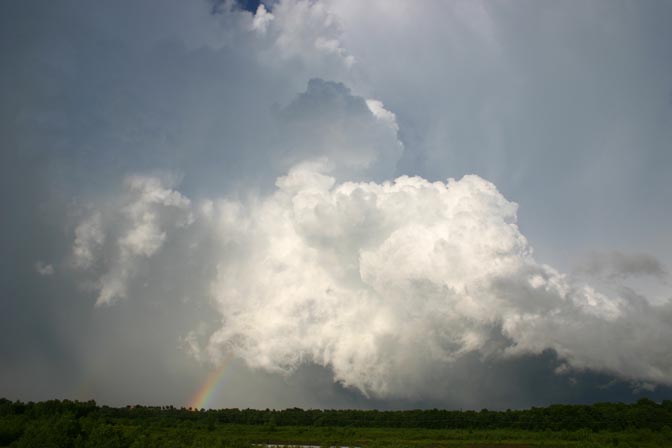
By the time I caught up again near Blackwell, he south end of the line of storms had become very low-based and very isolated from any surrounding clouds, so it was well-lit and photogenic. I think once it moved over the area that had earlier gotten heavy rain, then hot sun, the rapid evaporation of the rainfall in the heat contributed to the very low base - over a period of 40-50 miles, the storms went from rather high-based to about as low-based as I have ever seen. Here's proof you don't need tornadoes to have a successful chase:
www.siue.edu/~jfarley/arkcity1.jpg
This pic was taken from just east of Arkansas City, KS.
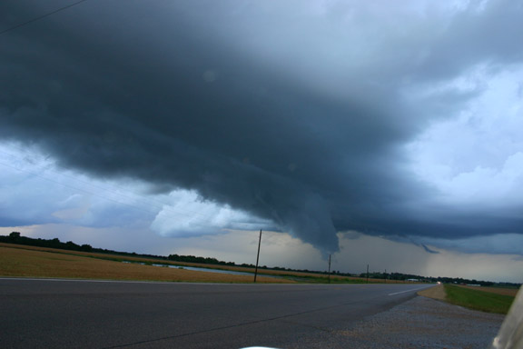
The updrafts near the tail end strengthened, and it tried to produce an RFD near Newkirk:
www.siue.edu/~jfarley/Newkirk.jpg
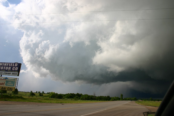
I finally lost the storm near Winfield, KS somewhere close to 8:00 p.m. Around this time, I noticed that new storms were going up west of the original line of storms, off to the west of Newkirk. Although these storms rapidly becamse numerous, they were less linear and more individual, as shown by this pic:
www.siue.edu/~jfarley/Winfield.jpg
This picture was taken near Winfield, KS just before sunset.
The trend of more individual storms continued after dark, as upper winds shifted to the west on the back side of the shortwave, creating better shear. Naturally, after dark and around the time (10 p.m.) that I found a motel in ICT ('twarn't easy, with the Special Olypics in town!), new storms in Cowley Co, KS produced multiple tornadoes. Such is fate in 2005! In fact, a tornado may have begun around 10 p.m. in almost the exact spot of the Arkansas City photo above. Wind damage was reported in that location, and a tornado was confirmed a short distance downstream (NE). Haven't seen a survey on that yet.
Here is the LSR for the wind report mentioned above:
PRELIMINARY LOCAL STORM REPORT
NATIONAL WEATHER SERVICE NORMAN OK
455 PM CDT FRI JUN 03 2005

0447 PM     TSTM WND GST     ENID                    36.40N 97.88W
06/03/2005  67 MPH           GARFIELD           OK   OTHER FEDERAL