I really wasn't paying much attention to weather today, expecting just garden-variety t-storms though maybe heavy rain. Starting to hear thunder around 3 or so, I checked radar in my office and was surprised to see a well-defined bow echo moving SE across NE MO. The thunder I was hearing was coming from a small cluster to t-storms forming over the N part of the St. Louis area.
I checked again a few minutes later - the bow echo was weakening, but the cluster of storms was strengthening. It moved slowly NE as the bow echo surged SE. I thought, "something interesting might happen when these merge." SPC apparently was thinking similarly and had issued a MCD for our area for possible isolated SVR along the outflow boundary from last night's storms that was triggering this convection. Too isolated, for a watch, they thought, though.
I checked again around 10 till 4 and saw the storms were intensifying, with several warnings issued to NW of STL. I went outside and thought it looked impressive enough to chase. I headed out just before 4, from the SIUE campus on the W side of Edwardsville a mile or so N, to check out a lowered area under the shelf cloud that stretched arcoss the northwestern sky. It had a little curlycue thing under it that made me think "scudnado," and in a few minutes, sure enough, KMOX radio said there had been citizen reports of a funnel cloud SE of Godfrey, IL (about 10 mi NW of where I was). It wasn't. I did briefly think the general lowered area might be a wall cloud forming on the front flank, but there was no rotation whatsoever so I am almost sure the whole thing was just outflow-related junk. This thinking is confirmed both by later views of the radar and by what I saw a few minutes later.
Thinking I was going to be overrun at that location, I poked back a mile or 2 SW, where I saw two larger lowerings to my north behind the shelf that looked like they went to the ground. I doubled back NE to investigate them, but once I got to where I had a clear view of them, where the SIUE road intersects IL route 143, it was obvious that they were outflow-related. The sky behind the shelf was very dark and had areas of a blue-green color - interesting, since I observed NO hail with this storm. I decided that if I stayed there I would get cored, and thought I MIGHT be able to beat the storm home and watch it go over from there. Wrong. By the time I got to downtown Edwardsville, which I had to go through to get home, I was starting to get overrun. Around this time, a SVR warning was issued for Madison County and some other parts of the St. Louis metro area.
I found a parking lot free of anything that might fall on me, parked facing the wind, and watched the show. Intense gusts which I would estimate peaked around 50 to maybe 55 mph (though one was clocked at 70 mph a few miles SE of where I was) and blinding rain; saw one small branch go down and a larger one already down. This intense rain and strong wind lasted for nearly half an hour. I called my daughter on the cell phone - she was also caught driving in the storm - and told her to park where a tree could not fall on her. Good advice, as several trees did go down on cars in Edwardsville, I later learned. The way people were driving around in an obviously intense and dangerous storm is amazing to me - no wonder cars get hit by falling trees.
Anyway, around 4:30 it let up and I drove home; saw several intersections just east of downtown Edwardsville completely under 6-10 inches of water so called in this street flooding. I saw a few branches down but no trees or powerlines. When I got home I had 1.3 inches in my rain guage but it is somewhat sheltered from the north (gotta find a better place!) so I am pretty sure there was really more - that's in addition to the 1.6 inches yesterday. Indeed, by 8 p.m. our lake had risen to the highest level I had ever seen.
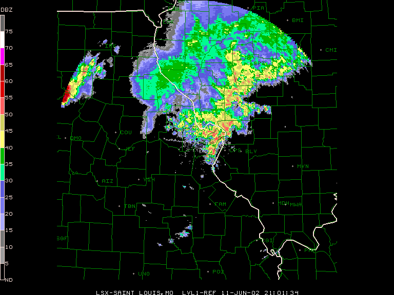
Not bad for a total chase distance of 10 miles or less! Looking at radar loops on TV when I got home it was amazing to see what the weakening bow echo did when it merged with the new convection just N of STL - went from practically nothing to awesome in a matter of minutes! LSRs from this storm can be found here, and a radar image of the storm can be found here. Believe me, these storms were more impressive than they looked on this radar - the surge of intensity in the storms with the merger of the line and the cluster occurred about 10 minutes after this radar image. Note also the new severe storms out to the NW over north central MO, which were later tornado warned. This complex weakened greatly by the time it reached the STL area, however.
Return to Weather Obervations page.