I headed out at 10:55, blasting north on I-55 figuring I could intercept it somewhere near the Macoupin-Sangamon Co. line, even with the rapid movement. Soon in prompted a TOR for Greene county, IL - and was now reported moving only 20 mph. Maybe it was turning into a right-mover, which would make the chase easier. Here is a radar image from around that time, showing the storm strengthening. I could see the rock hard tower as I headed up 55, but soon it became obscured by gunge, which was the story for the rest of the day.
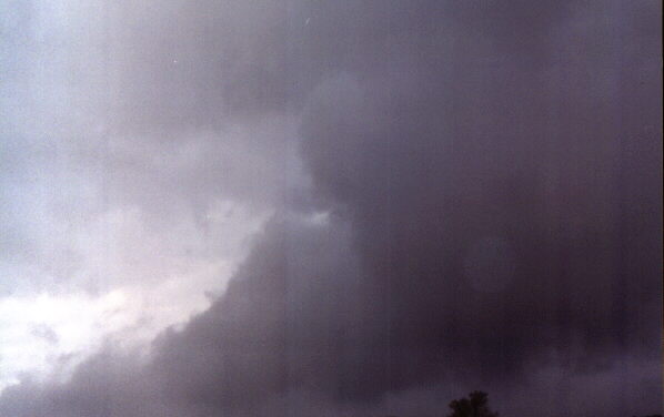
Shortly after a new SVR was issued for northern Macoupin Co., (with the reported movement now back to 65 mph), I intercepted the storm near Girard, IL. As I drove west toward the storm, the sky became very dark and threatening, and I began to see some CG. The storm looked like it was backbuilding, and I could see a bit of an updraft tower to the southwest, so I decided to work my way SW on 4 toward Carlinville. I thought the main updraft might be southwest of the intense precip area, and maybe moving more slowly or to the right, based on the earlier TOR warning. When I got south of Girard a bit, I stopped to look at the storm - very low, scuddy base, lots of CG, but no pronounced lowerings anywhere, despite the general low base. The one and only picture I got of the storm can be seen here. This looks like it could be an impressive lowering, and I now know (though could not tell then with all the gunge) that it was under the updraft. However, the clouds were this low along the entire leading edge of the storm. This would have been just before noon, though I forgot to check the exact time. Soon I was in outflow, and could see dark sky to the southwest, so I thought the thing to do was move south and get back ahead of the line as it backbuilt. BAD DECISION! If I could have had real time access to this radar image, I would have known better and gone north. But I didn't, and what limited view I had suggested the storm was backbuilding and lining out. (It was, in fact, merging into a squall line, but as it turns out it retained its supercell character long after it had become part of the line.)
Soon I was back in inflow and turned west toward the area of darkness - but the closer I got, the more outflow dominant it looked, so I headed back the mile or two east to route 4, where I made another crucial mistake. At that time I saw two lowerings to the northeast. I thought the right-hand one was the leading edge of the shelf cloud that had overrun me, so gave it little thought. The one to the left looked a little like a wall cloud, but it quickly broke up into a scattering of non-rotating scud. Rather than going after it, I decided to position myself for the oncoming storms to the SW. Nothing I had seen in the storm now to my NE led me to think it still had supercell characteristics. WRONG! Shortly later, a new TOR was issued on the storm I had let go. AARGH! Although the storm did merge into the squall line, it kept its supercell characteristics, and as it raced away from me at 45-50 mph, it eventually produced a NWS-confirmed tornado near Monticello, between Decatur and Champaign. From there, the storm continued into Indiana and Michigan, and was apparently responsible for some (though not all) of the 7 tornadoes that occurred in the Fort Wayne, Indiana CWA, and possibly for another around Detroit. The storm evolved into an HP by the time it produced the Monticello, IL tornado, and apparently also had that characteristic when Chris Novy videotaped an apparent rain-wrapped tornado west of Champaign, IL. I don't know if I could have kept up with the storm as far as Monticello as fast as it was moving - most likely I could not have - but it sure was a big mistake not to try. FWIW, here is a radar image showing the HP character of the storm around the time of the Monticello tornado.
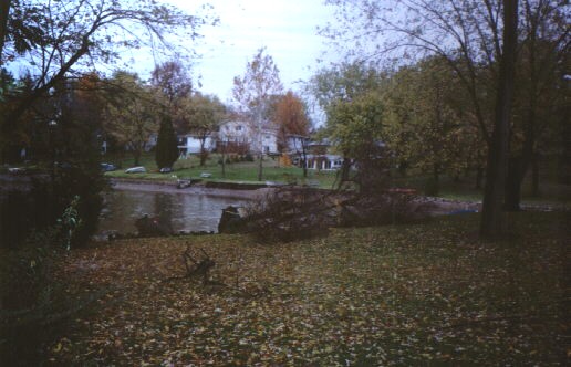
Thinking I needed data, I headed back to I-55 and checked the DTN monitor at the rest area just north of the Taylorville exit. Another mistake, because this allowed the storms (now a squall line, except for the imbedded supercell southeast of SPI) to overrun me, with the main result being a nasty drive home in blinding rain and perhaps marginally severe outflow wind. I hoped by going south on the freeway I could get back ahead of the line or at least be in position to do so when I got to I-70, but with the average storm movement now east at 55 it was impossible. (Note in the last radar image above, from around 1:30, the storm had overrun virtually all of Madison County.) So I came home, and saw the only significant wind damage I saw all day - in my back yard, where a 20-foot tree was uprooted. That seems to fit the whole chase today.
Here is a picture of the uprooted tree in my backyard. In this picture you can see that a wagonwheel that had been leaning agaist the tree stayed right with it as the tree went down (the white thing on top of the tree). A 12-inch block of wood that was part of a border for a beach area was also pulled right out of the ground with the tree's roots. (The metal around the tree near its base was to protect it from the beavers that live in our lake. Fat lot of good that ended up doing!)
Total chase distance: About 130 miles.
Return to Weather Obeservations page
This page was last modified October 28, 2001.