I succeeded in getting to route 140 ahead of the storm this time, with rapidly darkening skies in the north. Stopping in a parking lot at the N edge of Hamel, I could see an area of precipiation to my north with some RFB to its southwest. This would be the next storm or cluster of storms to the NE of the tornado-warned storm, probably the one that produced dime hail in Litchfield at 8:35. There were a lot of scuddy lowerings and what looked briefly like a wall cloud and RFD, but I don't really think it was. After a few minutes I decided to head west. As I did so a new TOR warning was issued until 9:15 for southern Macoupin Co, based on radar indication of rotation near Brighton. This would have been farther west than where I was looking at the RFB so probably was associated with another cell north of the one that prompted the original warning. As I went west on 140, I realized that I had never really been aware of how many trees there are along that road; I never got a clear view until I got almost to 159, still a little ahead of the approaching storm. To the west was precip associated with the original storm, not looking all that impressive, though it did have some nice CGs. I was briefly fooled by a "smokenado" over Wood River to my SW, but quickly realized it was smoke, not a tornado. To my NW was the most threatening-looking area, a dark area of heavier precip with a striated structure on its leading edge. This may have been an HP meso associated with either with the storm that prompted the first TOR warning or the next storm north which led to the second warning.
I decided it was time to retreat back to Hamel if I wanted to stay out of the hail. I figured when I got there I could either continue east, get under the roof of a gas station to get out of the hail, or return to Edwardsville. Meanwhile the sky was quickly darkening to my SW, suggesting development of a new cell over or just N of Edwardsville. I also heard soon that this storm had become SVR-warned as it developed earlier on the MO side and moved toward Madison Co. I debated whether I could beat this back to the next exit south, finally deciding that I could and had better, since otherwise it might cut off any return route. At the last minute, I got on I-55 and headed south. The sky was fairly bright ahead of me, but rapidly darkening to my SW. I decided to call Alice to see what was going on at home. Heavy rain and thunder, she told me; no hail. Just then the other phone at home rang (we have two lines), and it was my daughter calling to be sure we knew the Edwardsville sirens were blowing. Alice said she could hear them. I told her to go to the basement and got off the phone. Just then, I heard a very loud bonk, then another, and soon a lot. I was getting pelted by 1-inch hail. This was approximately 9:05 a.m. Between this and the blowing sirens, this storm had my attention! Soon I could see a NW-SE alligned RFB ahead of me, leading back to the intense storm over the northern part of Edwardsville.
The hail let up and stopped as I got to Il route 143. I decided I could head toward Edwardsville; since route 143 runs WNW and ESE, I could always turn around and retreat if the situation seemed threatening. When I cleared the wooded area, I saw what appeared to be a surging wet RFD gust front to my west, and general darkness to the NW over much of Edwardsville. Under the gust front was a short, stocky lowering. I thought possible funnel at first, but I looked carefully at it, and neither it nor the clouds around it showed any rotation whatsoever. Additionally, on the front side of the RFD gust front was not a likely place for a funnel or tornado, so I am very sure it was not a funnel. I decided at this point that any tornado with this storm was likely rain-wrapped and the best course of action would be to go home and join my wife in the basement. As I turned into the driveway, I heard the sirens blowing a second time. Altough no NWS warning was issued the first time they blew, this time the sirens were followed in a minute or so by the tone on the WX radio announcing a tornado warning based on a report of a tornado at route 159 and Park Ave. in Edwardsville. Soon intense rain and 40-50 mph winds arrived, but no hail and no wind stronger than that. That was pretty much it - we had a lot of rain and thunder for the next hour or so, but nothing severe. Once things settled down a bit I reported the hail through e-spotter; I delayed the report because the storm was already warned on and because I figured at the time NWS had its hands full with the possible tornado situation.
My first inclination was to believe that the tornado report was completely bogus, suspecting someone had seen the non-rotating lowering I had observed in a part of the storm unlikely to produce a funnel or tornado. In fact, I now know that there was indeed a funnel cloud farther west, although as best as anyone can determine it never touched down so there was no tornado. I have had a couple email communications with the spotter who observed the funnel, as well as with an astronomer who was with the spotter. Both report seeing two needle-like white funnels just ahead of the rain area, and probably partially wrapped in the rain. The funnels rotated around each other and may have merged into one before disappearing in the rain and trees that obstructed the spotters' views. There was some confusion initially about the location of the sighting, since it was reported as route 159 and Park Ave. Problem is, there is no Park Ave. in Edwardsville; just Park St. and Park Place. Though many assumed the report meant Park St., it in fact referred to Park Place, since the sighting occurred at the Edwardsville Children's Museum near the LeClare water tower, near the intersection of Troy Rd. (Route 159) and Park Place. The funnel was just WNW of there, apparently moving toward the ESE as it passed behind the water tower. The observers reported watching it for 15-20 seconds before losing sight of it. Their reports are consistent with those of an Edwardsville police officer who reported observing a similar structure on Poag Road near SIUE; that report was the reason for the first activation of the sirens.
I would like to emphasize that none of the observers saw any dust swirl or debris cloud; nobody could observe the funnel(s) make any contact with the ground (some could not tell because of trees), and no damage was reported anywhere in Edwardsville. I drove around the areas the funnel would have passed over and could see nothing but a few very small branches down, as was the case all over town. Therefore, I am quite sure there was no tornado, though it is listed as such in the preliminary LSRs (which also contain my hail report). I am, however, equally convinced from the eyewitness reports that there was indeed a funnel cloud - right where it should have been in this HPish storm, near where the inflow band intersected with the precip wrapping around on the W and S.
I would like to have chased in west-central Illinois this afternoon and evening when the real action occurred with a significant tornado outbreak from northeast MO to central IL. However, that was not to be. I had to attend SIUE graduation Saturday afternoon at 5, which took me out of the action. So aside from this morning action, I missed the big day.
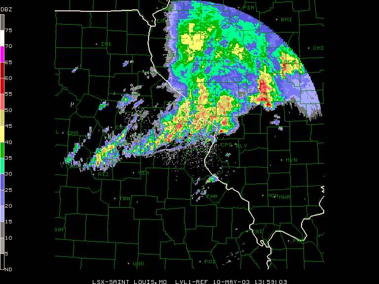
Here is a radar image from around 9:00 a.m., just before I encountered the hail. The southernmost of the two cells in Madison Co. is the Edwardsville storm; the cell to its north is the one that produced the original tornado warning and the one north of it, the warning for the Bunker Hill area. I think that the cluster of strong storms two counties to the NE is the one I was initially watching in Hamel.
Total chase distance: About 50 miles. I may add a couple pictures later if any of them come out.
Lessons learned:
1. Clusters of storms like this are hard to chase - especially when there's lots of low clouds/gunge ahead of them.
2. (For the 3rd time this week) If you are near the updraft of a strong storm, you may encounter hail, even if it looks like there is little or no precipitation there.
3. If there are multiple storms close together, the best action in terms of mesos and rotation may shift toward the south.
4. Don't assume that other spotters who reported something different from what you saw were looking at the same thing you were.
5. It is hard to see the best storms when you have competing responsibilities.
6. Along roads in your area, you may remember more stretches of road with good visibility than there really are when you are trying to track a storm.
Return to Severe Weather Observations page