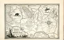
Map by George Annand in Powder River: Let 'er Buck.
Mapmakers Annand and Palacios
Each of the books in the Rivers of America series begins with a map of the featured river. Twenty-eight of these maps are by George Annand, and thirteen are by Rafael D. Palacios.
Annand maps
George Annand drew the map for the first book in the series, Kennebec: Cradle of America, published in 1937. He went on to illustrate more than half of the series books published through 1955.
Annand drew classified maps for the United States government during World War II. According to his daughter, he also worked at some point for the National Biscuit Company doing in his words "paintings of Fig Newtons in their native habitat." Otherwise, Annand preferred to freelance, contracting independently with the series publisher to provide the Rivers of America maps.
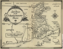
Annand's Powder River map (in Powder River: Let 'er Buck, 1938) reflects traditional cartographic techniques and aesthetics still popular in the early 20th century. Mountains are represented by concentric hachuring. Annand fills the map's white space with relevant vignettes portraying Wyoming as the land of bison and bucking broncos. The map's cartouche is embellished with a teepee and Indian in the mountains. Even the compass rose is decorated with steer horns. A later map by Annand in Salt Rivers of the Massachusetts Shore (1951) is less decorative and includes a linear scale. A whimsical sea creature frolics in the waters southwest of Martha's Vineyard.
Palacios maps
Rafael D. Palacios was born in the Dominican Republic and grew up in Puerto Rico. An artist and cartographer, Palacios began providing map illustrations for books in the late 1940s. He specialized in drawing maps of military battles, notably for Bruce Catton's works on the Civil War.
Palacios took over as the cartographer for the Rivers of America series in 1956. The last thirteen books in the series contain maps by Palacios.
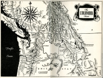
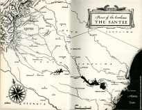
Palacios' maps exemplify the simpler and more naturalistic approach to cartography that was trending by the early 1960s. There are no topical vignettes, and the cartouches are abstract rather than scenic. Palacios' lettering is more uniform than Annand's. Only a neat line frames the Columbia River map (from The Columbia, 1956). Palacios' map of the Santee (from River of the Carolinas: The Santee, 1956) has no border at all. The morphographically depicted mountains on the map of the Columbia sprawl across two pages.
Map by George Annand in Salt Rivers of the Massachusetts Shore.
Map by Rafael D. Palacios in The Columbia.
Map by Rafael D. Palacios in River of the Carolinas: The Santee.
-- Written by Mary Rose
References:
Annand, George. For a list of Rivers of America books featuring maps by George Annand available at Lovejoy Library, click here.
Burt, Struthers. Powder River: Let 'er Buck. Illustrated by Ross Santee. Rivers of America. New York: Farrar & Rinehart, 1938.
Coffin, Robert P. Tristram. Kennebec: Cradle of America. Illustrated by Maitland de Gogorza. Rivers of America. New York: Farrar & Rinehart, 1937.
Fitzgerald, Carol. The Rivers of America: A Descriptive Bibliography. New Castle: Oak Knoll Press, 2001.
Holbrook, Stewart Hall. The Columbia. Illustrated by Ernest Richardson. Rivers of America. New York: Rinehart, 1956.
Howe, Henry Forbush. Salt Rivers of the Massachusetts Shore. Illustrated by John O'Hara Cosgrave II. Rivers of America. New York: Rinehart, 1951.
Palacios, Rafael D. For a list of Rivers of America books featuring maps by Rafael D. Palacios available at Lovejoy Library, click here.
Raisz, Erwin. General Cartography. New York: McGraw-Hill, 1948.
Raisz, Erwin. Principles of Cartography. New York: McGraw-Hill, 1962.
Savage, Henry. River of the Carolinas: The Santee. Illustrated by Lamar Dodd. Rivers of America. New York: Rinehart, 1956.