Ingolf Vogeler,
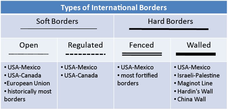
Types of International Borders along the U.S.-Mexico Border
![]() The Changing United States-Mexico Border
The Changing United States-Mexico Border
The U.S.-Mexico border is used to illustrate how the changing geo-political circumstances between the U.S. and Mexico have resulted in the expression of each of the seven border types, discussed earlier, along this international border. The 2,000-mile border is the longest border between a rich country and a poor one in the world; thus, it represents the sharpest divide in average income of any place on earth! Gross Domestic Product (GDP) in the USA was $ 47,422; in Mexico, $14,932 in 2009.
Open border
At the end of the
Mexican-American War (1846–48),
the
Treaty of Guadalupe Hidalgo,
by which the United
States took about 50 percent of Mexican territory,
established the current international border between the United States
and Mexico. Throughout the nineteenth century, the border
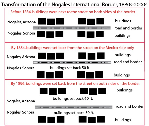
was essentially open to the movement of people and goods. The
diagrams on the left show the gradual
changes, as buildings were being set back farther and farther from the
international line.
Information from Arreola (2001) was used to construct the transformation
of the Nogales international border from the 1880s to 1890s.
Controlled border
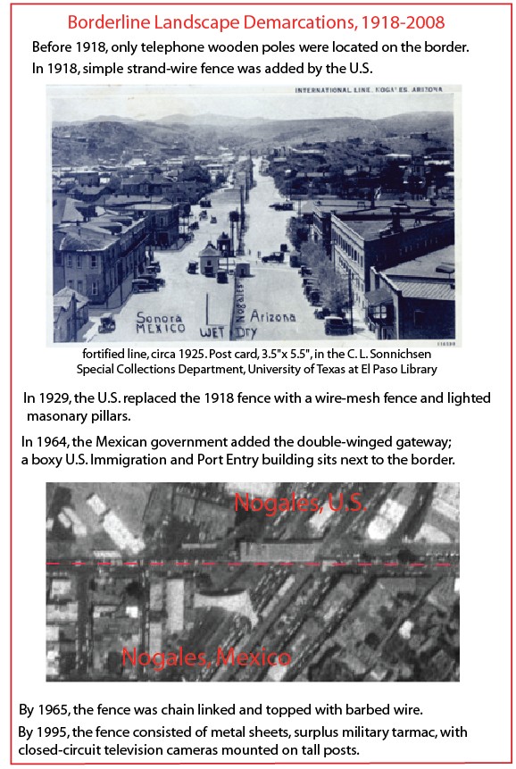
Starting in the late1910s, the
United States began to control the border with Mexico, at least at major
highway crossings, as shown in the postcard of
Nogales (left).
Fortified
fenced border
Nogales is used to illustrate the changing fortified border along
this international line. In 1918, a simple
strand-wire fence was erected on the U.S. side of the border in
Nogales, creating the first type of fortified borders. In 1929, the U.S.
replaced the 1918 fence with a wire-mesh fence and
lighted masonry pillars. And by 1965, the fence was
chain-linked and toped with barbed wire.
Fortified
metal walled border
By 1995, the border fence at Nogales and at most other urban
crossings consisted of metal sheets (surplus
military tarmac) with closed-circuit television cameras mounted on tall
posts. Beyond these border crossings, the border remained
essentially open.
The
transformation of the Nogales borderline landscape from 1918 to 2008 is
also based on Arreola (2001).
 Fortified
fenced border
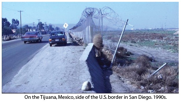
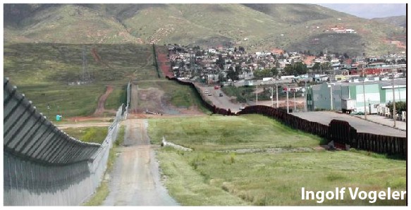
Fortified
fenced borderAs late as the 1990s, the U.S.-Mexico border in Tijuana, Mexico, was still largely "open," as shown by this photo. A truck had crashed into the razor-sharp wire atop the border
 fence
between San Diego and Tijuana,
allowing "illegal" immigrants to "easily" walk into San Diego,
especially under the cover of darkness! Signs such as the
CAUTION one shown are commonly seen along major
highways in the San Diego metropolitan area where undocumented
immigrants move away the border.
fence
between San Diego and Tijuana,
allowing "illegal" immigrants to "easily" walk into San Diego,
especially under the cover of darkness! Signs such as the
CAUTION one shown are commonly seen along major
highways in the San Diego metropolitan area where undocumented
immigrants move away the border.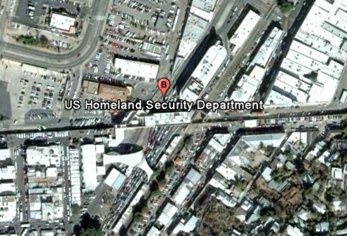 Fortified
walled border
Fortified
walled borderDuring the 1990s, the United States government started to add steel walls and to upgrade wire fencing in and around urban areas along this international border, as the Nogales example shows.
The Nogales border crossing in October 2010 (Google Earth).
Militarized border
Since 1995, the U.S. government has spent over 200 percent more on
border enforcement while the estimated number of illegal immigrants
living in the U.S. has increased by 57 percent!
President Obama promised to send 1,500 armed
National Guard troops to the five border states of California, Arizona,
New Mexico, and Texas. In August 2010, additional National Guard troops
were sent to Arizona, but Senator McCain argues that 3,000 troops are
needed along the whole border (Source: CNS News,
http://www.cnsnews.com/news/article/72068,
accessed 2 September 2010).
When Mexicans move
within their own country, especially to large urban centers and to the
U.S. border for jobs and a better standard of living, this is called internal migration. But when they continue to
move across the U.S.
border without "proper" papers, they become illegals. Indeed,
the presence of the U.S. international border creates illegal
immigrants. Ironically, almost
all illegals seek jobs in the former Mexican territory acquired after
the U.S.-Mexican
War, which is now called California, Arizona, New Mexico,
Nevada, Utah, and Colorado.
About 85 percent of all people who
immigrate to the United States do so legally. Only a small minority of immigrants cross the border illegally; 60
percent enter with visas and become "illegal" when they overstay their
visas. Most illegal immigrants are Asians and Europeans, not Mexicans
(Laws 1996).
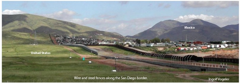
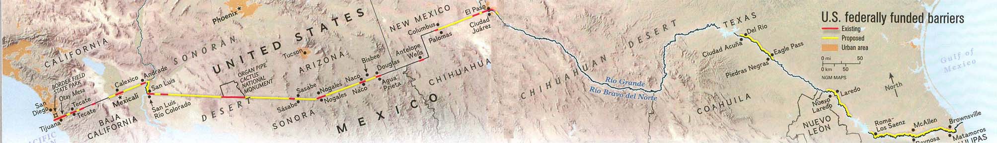
About 250 miles of the 1,952-mile border have varies kinds of barriers, from simple single wire fences to double wire-mesh fences to metal sheets; 700 additional miles of barriers were authorized by the U.S. Congress in 2006. U.S. federally-funded existing (red) and proposed (yellow) barriers along the U.S.-Mexico border are shown on the map below (Bowden 2007).
Click on the map to enlarge it.
 U.S.
Border Patrols, monitor signals from hundreds of sensors scattered
throughout the desert, and Predator
drones
(pilotless aerial vehicles 36 feet
long with 66-feet wing span remotely controlled) are used to control
this international border.
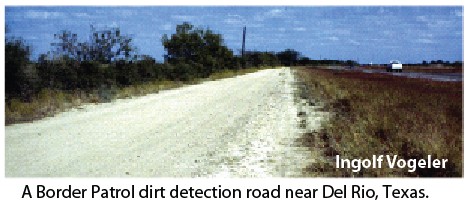
U.S.
Border Patrols, monitor signals from hundreds of sensors scattered
throughout the desert, and Predator
drones
(pilotless aerial vehicles 36 feet
long with 66-feet wing span remotely controlled) are used to control
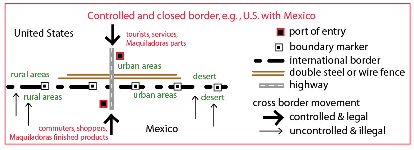
this international border. Identical to dirt detection roads along most of the Iron Curtain in East Germany, the U.S. Border Patrol maintains dirt detection roads (parallel to a state highway) along the Texas-Mexico border to detect illegal migration footprints. Helicopters and ground patrols then hunt down the illegals. After each rainfall, these roads are groomed.
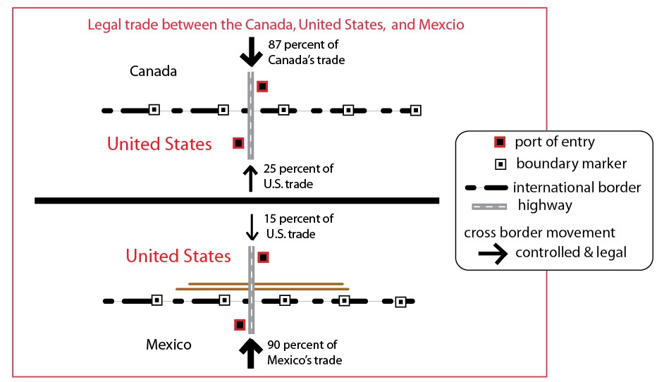
The U.S.-Mexico border has gone from a soft border to a hard border in less than twenty years (see diagram below):