Ingolf Vogeler,
Department of Geography, University
of Wisconsin, Eau Claire, WI
54702-4004, conducted field
research
along and on either side of the German-German border in 1965, 1967, 1976,
1989, 1994, 1998, and 1999. The results of this long-term research are presented
here for the first time.
In this study, ordinary cultural landscape features are dialectically related to hegemonic forces. First, the East German and Russian states expressed their hegemony along the western German border in response to the actions of the West German state and the Allies. Subsequently, the West German state expressed its hegemony along this border by eliminating as quickly as possible landscape traces (as well as political, economic, and cultural instituitons) of the former East German regime.
The Division of Germany and the Iron Curtain
The division of Germany was fundamentally a U.S. government
decision. After Roosevelt's death, liberal New Dealers were replaced
by administrative conservatives who were determined to rebuild postwar Germany
and to integrate it into the capitalist economies of Europe (Eisenberg 1996:
9). So when Churchill made his famous statement "from Stettin in the Baltic
to Trieste in the Adriatic, an Iron Curtain has descended across Europe,"
he did not mention that the Western powers had brought down this Iron
Curtain, not the Soviets as has usually been interpreted in the West.
Consider the following sequence of events.
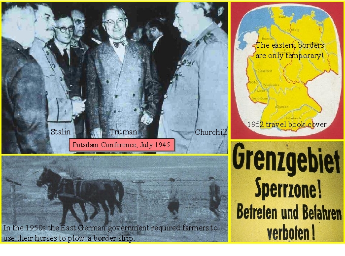
At the Potsdam Conference in July 1945 Truman, Roosevelt, and Stalin divided Europe into their own spheres of occupation and influence. By September 1949, the Federal Republic of Germany (FRG), more commonly called West Germany, had unilaterally declared independence. The German Democratic Republic (GDR), more commonly called East Germany, declared independence the next month, October 1949.
U.S. officials recognized that the Russians wanted Germany to remain united, but the Western powers, particularly the U.S. and British governments, were not willing to accept the Russian demands for reparations, "for quadripartite [the four powers division: U.S., United Kingdom, France, and U.S.S.R.] controls in the Ruhr, for a breakup of the large German combines [corporations], for denazification of [corporate and government] management, [and] for a politicized [progressive, indeed, leftists] labor movement" (Eisenberg 1996: 489). "In violation of the quadripartite framework established at Yalta and Potsdam, they [Americans and British] had opted to fuse their two zones economically (December 1946), to incorporate western Germany in the Marshall Plan (July 1947), to implement a separate currency reform (June 1948), and to convene a Parliamentary Council for the establishment of a West German state (September 1948)" (Eisenberg 1996: 485). In response, the Soviet representative withdrew from the Allied Control Council.
On June 24, 1948 the Soviets announced that the four-power administration of Berlin had ceased and that the Allies no longer had any rights in the Soviet sector; and then the Soviet occupation forces in eastern Germany began a blockade of all rail, road, and waterways between Berlin and the West. On June 26, 1948, the United States and Britain began to supply the western sectors of the city with food and other vital supplies by air. The West Berlin blockade and airlift lasted from June 26, 1948, to May 12, 1949, until the blockade was lifted by the Soviet Union. The airlift cost $224 million (Encyclopædia Britannica Online).
With the inception of the Berlin blockage, Truman argued that the Russians had trampled the wartime agreements in their ruthless grab of the former German capital and eastern Germany. He did not explain that the U.S. had abandoned the Yalta and Potsdam agreements and that it was pushing for the formation of a West German state against the misgivings of many European governments (e.g., France wanted a neutral Germany), as well as, many European people who feared a strong Germany, and that the Soviets launched the Berlin blockade to prevent partition (Eisenberg 1996: 491). Consequently, the Cold War took its most menacing form in occupied Germany, expressed in the division of the country and Berlin.
The German-German Border
and the Hegemonic
Border Landscapes
From 1945-1951 the German-German border was
fairly
easy
to cross, but by 1952, the East German government declared a closed border
zone and cross-border traffic was restricted and difficult. In 1961 "the
border was strengthened and guarded more than any other political frontier
in the democratic world" (Lenz 1983: 250). By the early 1950s the East
German government
was actively protecting its border against the West.
Farmers were being required to plow strips of
land
behind the border. Ironically, the West German government, and most
of its
population, refused to accept the German division it had created by its
unilateral declaration of independence! For example,
1950s travel books showed not only the temporary
nature of the German-German border but also of the German-Polish
border!
The East German government expressed its hegemony along the eastside of the German-German border by the eradication of village landscapes and depopulation. Approximately 100,000 "dangerous" people were forcedly resettled away from the 5-km (3.1-miles) border zone (Weisbrod 1992: 75).
The West German government expressed its hegemony along the westside of the German-German border by promoting new settlement through financial aid and tax incentives. By 1959, a 40-km (25-miles) wide planning area was created along the East German and Czech border. Federal and state governments supported the creation of social facilitates, such as schools and swimming pools; new housing; improvements in infrastructure, such as roads, water and sewage treatment plants; and job creation (Lenz 1983: 252).
With reunification the German government expressed its hegemony along the former German-German border by the eradication of the landscape features of the Iron Curtain. "When one group imposes its well-being over the places of another, the former completely or partially replaces the landscape symbols of the latter" (Falah 1996:256). With the reunification of Germany in 1990, the FRG was called Western Germany and the former GDR was referred to as Eastern Germany.
After reunification, the border and its landscape features were "out of place;" and therefore had to be eliminated as quickly as possible. Cresswell (1996:11) points out that the metaphor of "out of place" does not distinguish between social or geographical place. Places always mean both. The German-German border was a place in both social and geographic respects. Before WWII, this future border area contained political state boundaries within Germany, but it was not a critical international boundary. From 1945-1989, it became both a political and critical border of Germany and of the Cold War. Since 1989, the border in this area had reverted to its pre-1945 status and function. The border places were transformed and re-transformed, largely through the eradication of border features, and yet, they could not be returned to their identical pre-1945 appearances. Despite efforts to annihilate the border landscape, it exists in obvious and subtle ways. Landscapes are created by authors, in post-modern terms, and authorities in power create particular meaning. Yet landscapes, like books, are subject to multiple readings despite the fact that some readings are encouraged more than others (Cresswell 1996:13).
This study presents the results of these Cold War hegemonic struggles within Germany as expressed in the relic cultural landscape of the Iron Curtain. The work of Foote (1997) on the landscapes of violence and tragedy as they appear in the United States is particularly relevant to this study of an international border. Of his four types of responses (sanctification, markers, rectification, and obliteration), the obliteration of places that the "winner" finds shameful and repulsive is most applicable along the former German-German border. Markers along this border are also used selectively. Learn how former East German border guard dogs remember the Berlin Wall.
This study consists of two parts:
1) diagrams
with illustrative photos of the border, and graphs of the
percentages
and numbers of border landscape features in 1989 and the changes in these
features from 1979 to 1989 -- listed
below.
2) various landscape examples
of what remains of
the former Iron
Curtain -- follow the arrow
at the top of the page.
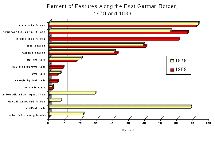
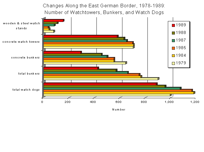
1979-1989
Changes in East German
Border Features
graph:
changes
in the percent of features along the East German Border in 1979 and
1989
graph: changes in
the number of features along along the East German Border,
1979-1989
Source: all the graphs were created by Ingolf Vogeler from data found in Ritter and Lapp (1998:165).
Berdahl, Daphne. 1999. Where the World Ended: Re-Unification and Identity in the German Borderland. Los Angeles: University of California Press.
Cresswel, Tim. 1996. In Place/Out of Place. Minneapolis: University of Minnesota Press.
Edwards, Rob. 1996. Fighting for life in the death strip. New Scientist. 149:12
Eisenberg, C. W. 1996. Drawing the Line: The American Decision to Divide Germany, 1944-1949. New York: Cambridge University Press.
Falah, Ghazi. 1996. The 1948 Israeli-Palestinian War and Its Aftermath: The Transformation and De-Signification of Palestine's Cultural Landscape. Annals of the Association of American Geographers 86(2):256-285.
Foote, Kenneth E. 1997. Shadowed Ground: America's Landscapes of Violence and Tragedy. Austin: University of Texas Press.
Lenz, Karl. 1983. Peripheral areas on the political borders of the Federal Republic of Germany. Manitoba Geographical Studies. 8:245-254.
Marcus, Greil. 1995. The Dustbin of History. Cambridge: Harvard University Press. N.A. 1993.
N. A. 1993. Restored links strengthen east-west co-operation. Railroad Gazette International. 149(7): 489-492.
Rasenberger, Hans. 1999. Die Dorfrepublik. Self published.
Ritter, Jürgen and Lapp, Peter Joachim. 1998. Die Grenze: Ein deutsches Bauwerk. Berlin: Ch. Links Verlag.
Weisrod, Bern. 1991. Grenzland: Annual conference of the Arbeitskreis für die Geschichte des Landes Niedersachsen, Göttingen, 1-3 October 1991. German History 10(1):74-79.