Weather Photos
All of these photos are Copyright 1997-2005 by John Farley, or by their owners if other ownership is indicated. You may download them
for your own personal use, but any other use requires permission. This page last modified November 9, 2005.

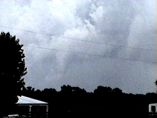
This apparent funnel cloud was one of several I saw near Carlinville, IL on April 7, 1998. More detail and photos on this storm can be found here.
Due to the growing number of pictures in this collection, I have indexed them by topic. Please select one of the following:
Lightning NEW PICS ADDED SEPTEMBER, 2005!
 ADDED JUNE 21, 2005! On June 13, 2005, I observed a tornadic supercell, which also produced up to golfball hail, over Jersey and Macoupin Counties, IL. The storm had a spectacular wall cloud, as well as this apparent funnel cloud near Medora, IL (video capture, contrast slightly enhanced). Just before this, it also produced an F0 tornado 2.5 miles north of Brighton, IL with a half-mile damage track. However, and unexpectedly, the tornado occurred not with the main mesocyclone/wall cloud, but about four miles south of it. Here is a video capture of the cloud feature associated with the tornado, taken around the time the tornado ended. Later, over western Macoupin County, the mesocyclone intensified again, with roation visible at the time this photo was taken.
On May 29, 2004, I witnessed a monstrous tornadic supercell that eventually moved all the way across Oklahoma. The storm produced several tornadoes, mostly low-contrast and often rain-wrapped. This video capture, enhanced due to the low contrast, shows an area that contained a rain-wrapped F2 tornado, SE of Thomas and west of Geary. The actual lowerings here, though, are probably cloud tags on the outer perimeter of the meso, not the actual tornado. I also saw anti-cyclonic rotation with what may have been the second or third of three tornadoes that occurred northeast of Calumet. This picture shows a brief needle funnel associated with the anti-cyclonic rotation, and in this video capture, taken a couple minutes earlier, the intense anticyclonic circulation could be seen, though there was no condensation funnel at this time. Earlier, the storm produced giant hail near Thomas. I saw stones over 4 inches in diameter, though this 2.5 inch stone is the biggest I got a good picture of. I also saw another possible tornado and at least 2 funnel clouds I did not manage to get pictures of. The storm produced other interesting lowerings, like this one and this one. And the lowering shown just behind the cab of the truck here may or may not have been a rain-wrapped tornado that occurred around sunset near Piedmont, OK.
On May 28, 2003, I got about 3 and a half minutes of video of a weak tornadic circulation about 3 or 4 miles northeast of Lincoln, IL. It was on the ground for at least 2 miles and at least 7 minutes as it tracked southeast. It formed under the flanking line of a supercell that produced several other tornadoes as well as baseball hail. Both of these pictures are digital video captures; in the first, the contrast is slightly enhanced.
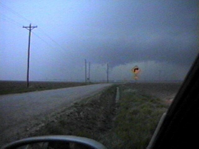
I got some low-contrast video of a tornado near Cordell, OK on May 5, 2001. The tornado can be seen above the sloping part of the white roof between two poles. The tornado is generally lighter in color than the background behind it, though a bit darker along the left edge. Here is an enhanced version of the video capture - it's more grainy, but the tornado is easier to see. Although the bottom of the condensation funnel is hidden by the building, the condensation never did go all the way to the ground - but the circulation did, for 4-6 minutes. People east of the storm got high-contrast pictures of the purplish tornado. The tornado apparently dissipated for a minute or two, then re-formed. This happened as I was trying to get out of town to get a better view; when I did, I was able to get a video capture of this feature; note what appears to be a pinkish funnel protruding in front of darker cloud base as the sun front-lit it. I think, in comparing to reports of other observers, that this was the re-formation of the tornado, but I am not sure. The tornado came from a spectacular storm that produced a nice beavertail and some interesting lowerings like this one and this one, along with low-level rotation for a long time before producing the tornado. The storm started out somewhat high-based and low-topped in its early stages, but after a couple hours it intensified rapidly, producing this partially rain-wrapped wall cloud then the tornado a few minutes later.
I videotaped this possible tornado near Red Bud, IL on April 15, 1998. Here is another video snap of the possible tornado, which was a few miles west of Red Bud. Here is a zoomed shot. Just after this last snap, a possible power flash occurred. The video shows a flash at ground level under the lowering - could be lightning but looks more like a power flash. In this most zoomed shot, what may be dust or debris can be seen under the lower right of the large lowering. Although I was too far away to tell for sure, this was reported by spotters as a tornado and is listed by NWS as a confirmed tornado in Storm Data. It was one of many that occurred that evening; most were farther east. I was also able to get a photo of the spectacular wall cloud that formed just before the apparent tornado. The storm also produced several other large lowerings under its flanking line, including this one near Ruma. This is NOT a tornado - just a large, wide lowering that formed when high-dewpoint inflow interacted with cold outflow.
Here are some video snaps of a tornadic storm in Macoupin County, IL May 12, 1998. Here is a large wall cloud with inflow tail northwest of Palmyra, IL (large file - may take a couple minutes to load - not converted to condensed jpeg due to low contrast). About 30 minutes later this lowering produced a tornado about 3 miles east of Palmyra, but a few minutes after the picture above it became obscured by rain so I did not see the tornado. Around the same time as this first lowering I also saw some beautifully sunlit and knuckled anvil from another storm to the southwest. A few minutes later and at a location a little to the southwest I saw this solid lowering that briefly looked like a funnel - but I could see little or no rotation. Then, it evolved into a more typical-looking wall cloud. This was located just southwest of Palmyra. Finally, on the way home I saw an apparent rain-wrapped funnel, located about midway in time and space between the two tornado touchdowns this storm produced. Video snaps of this feature and further explanation can be found here.
Brent Beasley has given me permission to post some photos of the F4 Marion, IL tornado (1982) and of a spectacular tornado near Mt. Carmel, IL. You can see these photos here.
I photographed this tornadic thunderstorm as it approached Evansville, IL on December 23, 1996. Begining
about five minutes after I took this picture from 3 miles NW of Evansville (which is
located about 50 miles south of Edwardsville), a tornado left a damage path
approximately 2 miles long and 50-70 yards wide through Evansville. The damage was rated F1. Several
homes and an old bowling alley were severely damaged in Evansville, along with
extensive damage to trees and power and telephone lines. A few minutes earlier
I took another photo of the same cloud structure and of
another cloud lowering just to the north of the one in
the other photos. Added on 2/21/97 - here is a zoomed version
of the picture above.
Here are some Snappy video captures of a series of apparent brief funnels that formed under or near the large lowering shown above, shortly before the Evansville tornado. Here we see what appears to be a funnel forming on the lower right of the large lowering. Soon it reached about 3/4 of the way to the ground. It was followed by this brief rope funnel on the front flank of the meso (right side of picture). In this final shot the large lowering has taken on more of the typical form of a wall cloud, with a small funnel again forming on the lower right. At that point I retreated; less than 5 minutes later the tornado touched down in Evansville.
On July 27, 1997, while returning from my high school reunion in Waterloo, Iowa, Alice and I saw a weak gust front tornado at the southeast edge of the Quad Cities area in northwest Illinois. There were cyclonically rotating clouds and a large dust swirl underneath, though no condensation funnel. In this series of photos, the rotation in the clouds above the dust swirl can clearly be seen. In the first photo, a gap can be seen between the lowest cloud tag in the front (from our view) of the area of rotation, which was moving to the right, and the lowest cloud tag in the back, which was moving to the left. In the second photo, the cloud tag in front has closed the gap and is moving in front of the cloud tag in the back. We also observed dust blowing to the left, away from us, and to the right under the rotating clouds. In the third photo, the lowest cloud tag in the front is now to the right of the lowest cloud tag in the back. All three of these photos were taken looking south from just north of the I-80/I-280/I-74 interchange. Earlier, we also got a nice photo of another strong storm from the Illinois welcome center where I-80 crosses the Mississippi River.
On May 6. 2003, I observed and videotaped a monstrous HP supercell near Union, MO. While viewing the storm I encountered inflow winds around 50 mph as an inflow band raced westward over my head into the storm. Lighting revealed scud as well as some suspicious lowerings under the area where the inflow band was racing into the storm. Both scud and a possible funnel can be seen in this video capture (at a point of maximum lightning illumination), as well as a lowering of an undetermined nature behind the building in the right center of the picture. In this picture, a larger rain-wrapped lowering is visible, again illuminated by lightning - but it is not possible to tell if it is a funnel, wall cloud, or something else. This storm did produce an unconfirmed tornado about 15 miles west of the location where I got this video, and a confirmed tornado as well as severe straight-line wind damage about 20 miles southeast. The storm stalled in its eastward motion around the time these pictures were taken, then turned sharply to the southeast as it interacted with a developing line of storms to its south. (On the first video capture, contrast is enhanced to make the cloud structure easier to see.)
The evening of June 14 - the same day a destructive bow echo storm had caused widespread damage throughout the northern part of the St. Louis area - this tornadic supercell moved just north of the St. Louis area, producing a damaging tornado in the New Douglas/Sorento, IL area. I took this picture around the time of the tornado - note the overshooting top. Also very evident was a rear flank downdraft slot. The storm was about 12 miles away when I took this picture.
Return to Top of Page
On August 14, 2004, Alice and I saw one of the most menacing wall clouds I have ever seen near Levy, New Mexico, given a slight pinkish tint by the incoming light. The storm was quite electrified, with the wall cloud illuminated by this CG lightning. Another bolt came from a slight lowering behind the wall cloud that was difficult to see except when backlit by lightning. This storm was a prolific hail-producer, covering the ground in some areas.
On July 5, a powerful storm moved across the St. Louis metropolitan area, producing winds to 90 mph and knocking out power to over 200,000 customers - some for 2 or 3 days. I got a picture of the storm and its shelf cloud just before it hit Chesterfield, MO with 70 mph wind, then more photos on the Illinois side as it produced CG lightning near Fairmount City and surged across the American Bottom area west of Edwardsville. It later produced a brief tornado between Edwardsville and Marine, which I saw but was not able to photograph.
On June 4, 2002, I photographed a spectacular shelf cloud between Eureka and Bloomington, IL. I repeatedly stopped to film the shelf cloud, then had to quickly flee as the storm approached. Spectacular! This storm produced gusts to 65 mph causing wind damage in several locations and hail up to 2 inches in diameter. It also produced a huge, wide dust plume most of the way up to the cloud base under shelf cloud to SSW. It looks like something you would see in Oklahoma or Colorado, not Illinois! A bit closer to me, the shelf cloud showed a sharp linear striation where it intersected with the parent cloud. I get a little more video of the spectacular, menacing shelf cloud as the storm is about to overrun me for the second or third time.
Chasing in a carvan with the ILCHASE gang (Mark Siefried, Scott Kampas, and Chris Novy) and with Blake Naftel in southern Illinois on April 21, 2002, I saw this large wall cloud and beavertail near Benton, IL. Chris Novy directed us toward a road to follow the storm as I got this shot of the wall cloud (video captures). I was also fortunate to get this this snapshot of the wall cloud and beavertail out the window of my car as we pursued the storm.
On August 18, 2001, I saw this possible funnel cloud southeast of Waltonville, IL about 15-20 minutes after a tornado occurred just south of Waltonville on August 18, 2001. Earlier, I photographed this spectacular supercell which produced the tornado and widespread reports of wind damage and hail to golfball size. Note the scuddy lowering extending nearly to the ground under the updraft. Here is a more zoomed picture of the lowering. These two pictures were taken about 20-30 minutes before the tornado occurred.
Always have a camera handy! I got this picture, one of my best storm structure shots ever, through the windshield of an airport limo! Note that the entire storm is included in the photo, including a brightly sunlit wall cloud that was in just the right place for the sun to shine on it through the RFD notch. As we got closer, we could see definite rotation, but the storm was already starting to weaken and the lowering dissipated about 15 minutes after this picture was taken. Although it looks like a tornado in the picture, the rotation apparently did not extend to the ground and no tornado or wind damage was reported with this storm. This picture was taken June 24, 2000 from near the intersection of I-255 and I-270 in Madison Co., IL, around 7:45 p.m. Earlier the same day, a tornado did cause considerable damage near Mascoutah and Millstadt, IL, about 30 miles south of this location.
I got some video captures of severe HPish storm between Carlinville and Litchfield, IL on April 19, 2002. It had quite a bit of CG lightning and a nice inflow band. It also formed this lowering which evolved into a large inverted-pyramid shaped lowering about halfway to the ground - which then wrapped up in rain and disappeared. It weak but rather persistent rotatation on radar, and along an E-W path through Carlinville near the area of rotation, there were a number of large hail and wind damage reports.
This apparent funnel cloud was one of several I saw near Carlinville, IL on April 7, 1998. A few minutes later it became wider but shorter, with another front-lit lowering to its right. Earlier I videotaped a needle funnel as the storm approached Carlinville, then a larger funnel just west of Carlinville. Here is a zoomed video snap of that funnel. The storm produced another narrow lowering southwest of Carlinville. This storm produced one-inch hail and prompted two tornado warnings based on radar signatures, but no tornadoes on the ground. This supercell was nicely backsheared, and was followed by another supercell that developed to its south and prompted at least two tornado warnings farther to its east. There were 20-30 tornadoes in Illinois that day; most were weak and short-lived.
On May 1, 1998, I videotaped a severe storm near Bunker Hill and Staunton, IL, about 20 miles north of Edwardsville. In this video snap you can see a lowering with hail shafts behind it and to the right. Soon the lowering took the form of a wall cloud with an inflow tail to its right. CG lightning zapped down in front of the lowering. The lowering persisted for 30 minutes under the storm's updraft, accompanied by frequent CG lightning. The storm produced heavy hail, which was up to an inch in diameter in some areas.
On June 12, 1998, I photographed this possible small, brief funnel cloud from across the street from my house. It was under a storm that developed behind (WNW of) a large supercell that had moved through Florissant and Collinsville earlier.
On June 6, 1997, Alice and I saw this spectacular cloud lowering on a storm in eastern Madison County, IL, near New Douglas. The lowering widened. It formed on the southeast edge of a wall cloud we had been watching for about half an hour, when a newly developing precipitation shaft on its rear flank merged with a weakening one on its front flank, creating an interaction zone between inflow and outflow. Cloud motion was clearly rising, but rotation, if any, was slow and weak so far as we could observe or see from the video. A short time later, I photographed this beautiful towering cumulus from the I-70 rest area near Highland. This developed into a storm merged with another to its south to produce large hail and wind damage in southeast St. Clair County. At the same time, a new storm developed northeast of Edwardsville and northwest of Marine, giving us a chance to photograph its brightly sunlit top through an opening in the dark clouds at its base. It, too, produced a wall cloud, as well as a lighting strike that sent smoke or steam rising from a field about 200 feet from our car as we drove past the field (sorry, no picture of this!). I did, however, get another good picture of the wall cloud.
Here is a Snappy video capture of the lowering produced by the first storm, taken from a couple miles southeast of New Douglas. In this second video grab, the lowering appears to take the shape of a funnel cloud, although neither our visual observation nor the video could confirm that rotation was occuring.
Check out this awesome lowering that Alice and I saw southeast of Terre Haute, IN on June 21, 1997. This feature, similar to the one in the section above this one (but this one was front-lit), formed on the southern edge of a wall cloud at the tail end of a squall line. A severe thunderstorm warning was in effect when I took this picture for Clay County, where the precipitation behind the lowering was falling.
On April 30, 1997, a severe weather outbreak occurred in Illinois. I photographed these
cloud lowerings, including a couple possible brief small funnels,
in a severe storm in Macoupin County that prompted a tornado warning and produced 1-inch hail
near Carlinville. A wide-angle version of this photo showing storm structure can be seen
here. Shortly thereafter, this tornadic
supercell developed about 10 to 12 miles to my east, and as it moved rapidly northeast it
produced twin tornadoes near the Montgomery-Christian county line. The dust in the foreground is from
high winds behind the cold front that caused the storms. Soon, I was in a dust storm myself.
On May 25, 1997, Alice and I saw a beautifully backlit storm in northeast Oklahoma. Alice took this photo showing a wall cloud/possible funnel with updraft tower above and intense precipitation shaft to the right. Soon, I got a shot of a second large wall cloud which appeared to extend to the ground, but this was an illusion created by its passage behind a hill. This wall cloud showed clear rotation. A third, non-rotating wall cloud developed before the storm sheared apart.
Here is a Snappy video screengrab of the apparent funnel cloud (5/25/97), taken from about 2 miles south of Jennings, OK looking west. Here is a video snap of the the second wall cloud, which at times showed rotation. The scud at the lower left of the wall cloud was rising rapidly upward and to the right at this time. In this third video snap, the wall cloud looked less organized, but the aforementioned feature had consolidated into a narrow, dark cloud - possibly a brief vortex swirling up into the wall cloud.
Finally, in 1977 I got some good shots of two lines of thunderstorms passing
through the Fargo, ND-Moorhead, MN area, where I lived at the time. First, I
photographed a brightly sunlit line of strong storms
that had just passed through the area. Note the rainbow near the bottom of the
cloud, just left of center in the photo. Then, I looked to my west and saw an
approaching low-precipitation storm with a classic wall
cloud. After this storm passed, it too became brightly
sunlit.
Return to Top of Page
ADDED NOVEMBER 9, 2005! On the evening of November 5, 2005, I got a couple nice lightning shots looking across Dunlap Lake as a line of severe-warned storms approached Edwardsville. In this shot, lightning illuminates updrafts of the approaching storm. As the storm got closer, CG and CC lightning occurred, as the gust front approached.
ADDED SEPTEMBER 20, 2005! A couple weeks after I got the pictures linked in the next item, I was able to get a nice shot of a bolt of cloud-to-ground (CG) lightning across Dunlap Lake in Edwardsville on September 18, and of cloud-to-cloud lightning on the back side of a line of severe thunderstorms on September 19.
ADDED SEPTEMBER 7, 2005! Here are the fruits of my first successful effort at getting lightning on a time exposure with a digital SLR camera rather than by capturing frames from video. The lightning occurred in the late evening on August 27, 2005. I was able to get a couple decent shots of the lightning, even though the storms were about 50 miles to my south southeast.
The following lightning pictures are all video captures. Although a couple of them also appear elsewhere in this photo collection with the documentation on the storms in which they were photographed, they are grouped here for the convenience of viewers interested in lightning photos.
On June 11, 1999, I videotaped these twin bolts in a pulse severe storm. This shot was taken from a couple miles north of Worden, IL looking south. Note the many branches on both bolts and between them.
On 6/21/97 south of Terre Haute, IN, Alice and I saw a spectacular CG, less than a mile away, backlit by the setting sun. Here is a Snappy video capture of this lightning.
CG lightning zapped down in front of a small wall cloud on this hail-producing storm in southern Macoupin Co., IL on May 1, 1998. The storm was accompanied by frequent CG lightning.
Return to Top of Page
Twice in 7 months, trees were uprooted in my backyard by high winds. This small tree was uprooted October 24, 2001 while I was observing a cluster of severe storms to the north of our area. And this large tree was uprooted on May 16, 2002 by high winds caused by a sharp pressure gradient behind a line of (non-severe) showers and thunderstorms.
In May, 1996, a microburst in a severe thunderstorm produced winds of 70-90 mph
in Edwardsville, producing damage throughout the southern and eastern part of
town. This is what my backyard looked like after that
storm.
On April 13, 1998, a tornado hit Edwardsville. Several businesses, a home, and a farm building suffered serious damage. Here are some photos of the damage.
On June 14, 1998, a severe downburst event produced this scene on my barbecue deck. Power was out for 8 hours and damage was extensive throughout the northern part of the St. Louis area.
In 1984, some large hail up to 1.5 inches in diameter
pummeled the Edwardsville-Glen Carbon area.
On February 27, 1999, a supercell moved through the St. Louis area producing over $16 million in hail damage and a brief tornado just north of Troy, IL. Here is a video snap of dime to nickel size hail pelting my barbecue deck, and here is a photo of hail up to golfball size still on the ground 20-30 minutes after the storm passed Illinois route 4 between Troy and St. Jacob. Parts of St. Louis got hial up to 2.5 inches in diameter.
Return to Top of Page
ADDED SEPTEMBER 7, 2005! On June 3, 2005, I was fortunate to photograph an unusually spectacular storm east of Arkansas City, KS, near the OK border. The storm was very low based (just a few hundred feet from ground to cloud bottom), and this combined with the bright sunlight and the rainbow made it a sight to behold.
ADDED SEPTEMBER 7, 2005! On August 9, 2005, Alice and I visited the Grand Canyon and were treated to this spectacular view of a storm across the canyon. Here is the same storm 15 or 20 minutes later, after it has dramatically intensified, forming a pronounced lowering. Not sure exactly what this was, since the storm was at least 30 miles away, but there were no reports of severe wx with this storm. Earlier in the same trip, I got this picture of mammatus clouds near Santa Fe, NM, and on the way home on August 17, I caught this shot of a line of thunderstorms with an updraft illuminated by the setting sun east of Amarillo, TX. Here is the sunlit anvil of the same cluster of storms.
On May 15, 2005, I photographed a high-based thunderstorm approaching Santa Fe, NM near sunset. These types of storms are common in the low-humidity environment of New Mexico. Like many of these storms, this one produced only light precipitation, but the storm was very pretty as it interacted with the sunset. Such high-based storms are much less common in Illinois, but some did form on May 27, 2005 as strong upper winds and a boundary forced what little moisture was available into high-based thunderstorms like this one near Valmeier, IL. After a while other storms developed to the north, producing more truly elevated convection over the cooler air near the surface north of the boundary and from the outflow of the earlier storms.
Here is a nice rainbow in a sunlint rainshaft on July 13, 2004 near Lake Shelbyville, IL. I missed this day's giant hail and tornadoes, but did get a couple nice cloud and rainbow pictures.
On July 21, 2002 a series of thunderstorms developed over the refinery complex in the Wood Rive/Hartford, IL area. Several showers and thunderstorms developed over the refineries during the period from 4:00 p.m. to 8:00 p.m. These storms were exceptionally photogenic from my home in Edwardsville, because they were directly between my location and the sun. They cast shadows over some cirrus debris from earlier convection, and the adjacent shadows and crespicular rays created spectacular arcs of light and shadow above the storms.
Check out this impressive overshooting top and backsheared anvil. The most unusual thing about this storm was its far northern location: I took this picture from a train between Talkeetna and Anchorage, Alaska on June 23, 2000.
In the summer of 1996, I took this picture of the top
of an isolated thunderstorm just north of Edwardsville.
Also in 1996, I got a good shot of a rainbow in front
of brightly sunlight cumulonimbus anvil while visiting my parents in Waterloo, IA.
If you want to see something that looks like a rainbow but isn't, click here to go to the winter weather section and look at the bottom photo in that section.
Here is a nice rainbow shot, taken near Benld, IL in March, 1998. I also photgraphed this cold-core cumulonimbus with front-lit precipitation shafts as it moved away from me that day. This cluster of storms later produced 1/2 - inch hail in central Illinois.
Here is another nice rainbow, again from a cold-core storm. This picture was taken May 23, 2001 in Glen Carbon, IL. Cold-core storms like these are great rainbow producers. Occasionally they also produce damaging wind, as some in Illinois did this day, and they can be prolific producers of (usually small) hail.
I photographed these mammatus clouds on the underside of a supercell's anvil over Leech Lake, MN July 20, 1998. Although the storm produced only a light thundershower at my location, it produced 3 tornadoes and several reports of wind damage in a line from NW of Detroit Lakes, MN to just north of Brainerd, MN.
On May 5, 1999, I got this video snap of some sunlit mammatus at the east edge of Edwardsville. Earlier, this storm produced a a beautiful backlit wall cloud as it moved between Collinsville and Highland. Earlier that day, I watched a splitting supercell near Marion, IL. I got this photo of the almost LPish left mover, showing a beavertail, vault, and back-sheared anvil to my south. The left mover weakened quickly after the split, but the right mover produced hail up to 5 inches in diameter near the darkened area at the left of the photo.
Here is another nice picture of sunlit mammatus. I got this picture a little north of Pere Marquette State Park in IL on June 4, 2000. The same storm also produced a nice rainbow and lots of anvil-crawler lightning.
On September 30, 1998 I photographed this elevated storm over Bloomington, IL. Although the base of the storm is higher than is typical for most Illinois storms, this storm was quite strong and just after this picture a bolt of CG lightning knocked the radio station I was listening to off the air briefly. Later that afternoon, I photographed this yellow-green area in the base of an approaching squall line. There are different ideas about what causes this kind of coloration; one is that it is due to refraction of light by hail. Whether or not that is true, this squall line did produce a burst of quarter to half-inch hail when it passed over a few minutes later.
I'm especially proud of this picture of a line of
thunderstorms approaching Edwardsville in the early 1980s, because it was shown
on the weathercast of KTVI, Channel 2 in St. Louis.
Here is a nice example of a roll cloud. The linear cloud under the base of the storm is separate from the base, although the separation may not show up well in the photo. This roll cloud formed when outflow associated with a new area of precipitation interacted with inflow to the storm's updraft. The white area near the top center of the photo is the storm's anvil; new towering cumulus can be seen to its left. This photo was taken near Litchfield, IL on June 9, 1999, looking north as this storm drifted northward away from me.
Return to Top of Page
ADDED FEBRUARY 26, 2005! Not much can beat the beauty of freshly-fallen snow. I took this picture in February, 2005 after an overnight snowfall at Dunlap Lake in Edwardsville, IL.
ADDED FEBRUARY 26, 2005! This picture looks like a line of thunderstorms, but actually it is a convective snowstorm over the Sangre de Cristo Mountains in far northern New Mexico. I took this picture looking NNE from about 10 miles west of Taos the day after Thanksgiving, 2005, after skiing in a snowstorm for most of the day at Taos Ski Valley. After this system passed over the mountains, thunderstorms did occur on the high plains of northeast New Mexico.
While skiing at South Dakota's Terry Peak on February 23, 2002, I observed the passage of a strong cold front that plunged temperatures from the 50s and 60s to well below freezing there and in much of the midwest. The front was clearly marked by a deck of low clouds and fog, seen here in the distance, then coming closer, and finally moving over the next ridge toward the ski area. Within a half hour or so of the latest photo, it enveloped the ski area in fog, and the temperature plunged.
One of the most memorable storms in this area was an intense snowstorm, accompanied
by thunder and lightning, that dumped 16 inches of snow on Edwardsville in
January, 1982. The snow overhung halfway to the ground
from roofs and buried cars in parking lots.
Speaking of snow, look at this picture of blowing snow
on the crest of the Continental Divide at the Loveland, Colorado ski area in
March, 1997. A few minutes after this picture was taken, a gust of 80 mph was
recorded at the top of one of the chairlifts. Later, two chairlifts were closed
when winds gusted to 90 mph. Above the blowing snow is a nice example of a
lenticular cloud.
Here is a photo I took on March 13, 1999 of freshly fallen snow clinging to trees in Santa Fe, NM, brightly lit by the morning sun.
Check out this view from the top of Vermont's Killington Ski Resort on December 29, 2000. Fog had coated the trees with frost and snow - nature's Christmas decorations!
A visual treat of winter weather in the colder parts of the U.S. can be found in the displays of sundogs and sun halos that sometimes occur. This sundog was part of a brilliant display that occurred in Waterloo, Iowa on December 21, 2000. The temperature was low, and ice crystals in the air near the ground led led to the brilliant display as they refracted light from the early morning sun (and again near sunset that day). This feature looks like a rainbow, but note that it is in a clear sky (and the temperature was way too low for rain). Apparently, this is a feature known as a circumzenithal arc. This feature seemed to appear where an outer (i.e. 46-degree) sun halo overlapped with its mirror image. Note that near the bottom of the picture, you can see the primary (inner, or 22-degree) sun halo. Sundogs form on this inner halo, at points horizontal from the sun to its right and left, and in fact the sundog shown earlier was on the right-hand side of this halo. An excellent Web resource on sun halos and sundogs, including such less common phenomena as circumzenithal arcs and 46-degree halos, can be found here. Thanks to Geoff Lewen for bringing this Web site to my attention.
Return to Top of Page
As always, more photos may be added later. If you are interested in detailed reports of my observations of some of these weather events, you can find them here, along with more photos taken during observations of other weather events. Also, if you are interested in links with current information on severe weather, some of my favorites can be found here.
Comments are always welcome.
Return to John Farley's home page.